London’s South Bank Walk is one of the most celebrated urban riverside routes in Europe. Stretching along the southern bank of the River Thames, the route combines centuries of history, world-famous landmarks, cultural institutions, and panoramic views of the British capital. Unlike many historic districts that developed behind city walls or around commercial centres, the South Bank evolved from a working waterfront into a major cultural and recreational destination visited by millions annually.
- What is the South Bank Walk and why is it important?
- How did the South Bank develop throughout London’s history?
- Which landmarks define the South Bank Walk today?
- Why has the River Thames been central to the South Bank’s identity?
- How did theatre and entertainment shape the South Bank?
- What architectural styles can visitors observe along the route?
- How has preservation protected the South Bank’s heritage?
- What makes the South Bank Walk one of London’s most scenic routes?
- Why does the South Bank remain historically significant in the twenty-first century?
Today, the route connects historic sites, modern architecture, theatres, galleries, public spaces, and bridges that collectively tell the story of London’s transformation from a medieval trading city into a global metropolis. The South Bank Walk provides an accessible way to understand the city’s geography, architecture, social development, and relationship with the River Thames.
What is the South Bank Walk and why is it important?
The South Bank Walk is a riverside pedestrian route along the southern bank of the River Thames that links major cultural, historical, and architectural landmarks while providing one of London’s most significant public spaces for recreation, tourism, education, and heritage interpretation.
The South Bank Walk generally refers to the pedestrian route extending from Westminster Bridge in the west to Tower Bridge in the east, although many visitors focus on the section between Westminster Bridge and Blackfriars Bridge. This corridor includes some of London’s most visited attractions and public institutions.
The route occupies land historically associated with industry, entertainment, shipping, and commerce. During the medieval and early modern periods, areas south of the Thames developed differently from the City of London. Regulations inside the City restricted certain activities, leading theatres, entertainment venues, and other enterprises to establish themselves on the South Bank.
The importance of the route lies in its concentration of cultural assets. National institutions, public art installations, performance venues, and preserved historic structures exist within a relatively compact riverside landscape. This combination creates an open-air historical and cultural corridor.
The South Bank also serves educational purposes. Schools, universities, heritage organisations, and researchers frequently use the area to study urban development, architecture, river transport systems, and cultural history.
How did the South Bank develop throughout London’s history?
The South Bank evolved from marshland and scattered settlements into a centre of medieval entertainment, industrial activity, transportation infrastructure, and modern cultural development through successive periods of urban transformation spanning nearly two thousand years.
The history of the South Bank begins during Roman London. Archaeological evidence indicates activity along both sides of the Thames shortly after the establishment of Londinium around AD 47. The river served as a transportation artery connecting settlements and facilitating trade.
During the medieval period, the South Bank became known for activities often restricted within the City of London. Entertainment districts emerged in areas such as Bankside. Taverns, markets, animal-baiting arenas, and theatres attracted residents and visitors alike.
By the sixteenth and seventeenth centuries, Bankside had become one of England’s most important entertainment centres. The area hosted several theatres that contributed significantly to the development of English drama.
Industrialisation during the eighteenth and nineteenth centuries dramatically altered the riverside landscape. Warehouses, docks, factories, breweries, and transport facilities expanded along the Thames. Railway construction introduced major engineering structures and transformed access to the area.
The twentieth century marked another turning point. Wartime damage, post-war reconstruction, and urban planning initiatives reshaped the South Bank. The Festival of Britain in 1951 became particularly influential. The event encouraged redevelopment and established the area as a cultural destination.
Modern regeneration projects continued throughout the late twentieth and early twenty-first centuries. Former industrial sites were converted into cultural venues, public spaces, residential developments, and tourism infrastructure.
Which landmarks define the South Bank Walk today?
The South Bank Walk is defined by internationally recognised landmarks including the London Eye, Southbank Centre, Shakespeare’s Globe, Tate Modern, Borough Market, and Tower Bridge, each representing different periods of London’s historical and cultural development.
The route offers a concentration of major attractions rarely matched elsewhere in London.
The London Eye, opened in 2000, rapidly became one of Britain’s most visited paid attractions. Its position on the Thames provides extensive views across central London and illustrates contemporary engineering design.
The Southbank Centre occupies a site linked to the Festival of Britain. It remains one of Europe’s largest arts complexes and includes performance and exhibition spaces that host international cultural events.
The National Theatre represents post-war British architecture and serves as one of the country’s leading performing arts institutions.
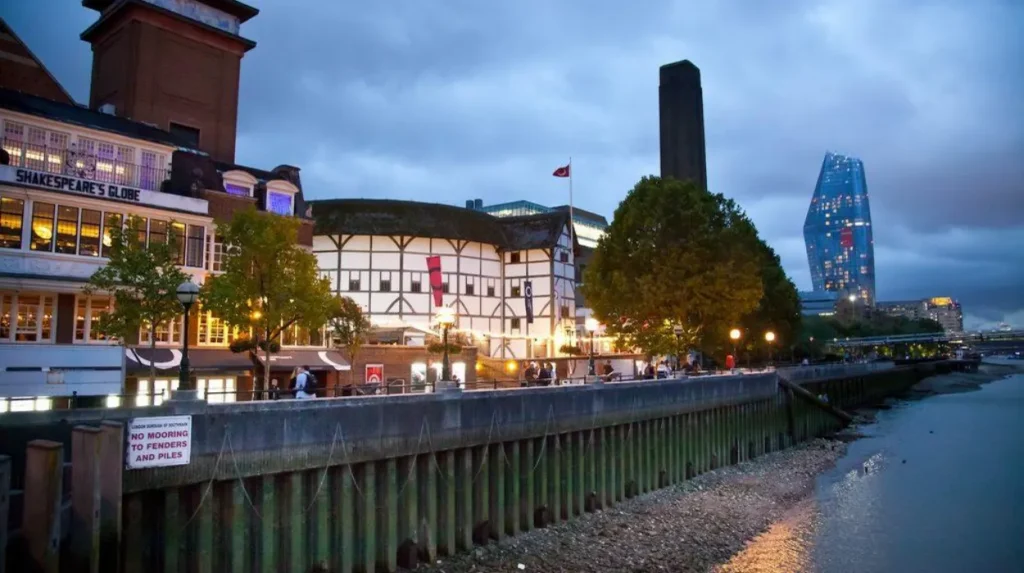
Further east, Shakespeare’s Globe reconstructs the style of Elizabethan playhouses associated with the era of William Shakespeare. The theatre provides insight into sixteenth-century performance traditions.
Tate Modern occupies the former Bankside Power Station. The conversion of an industrial structure into an internationally renowned art museum exemplifies modern urban regeneration.
Borough Market reflects the area’s longstanding commercial history. Historical records indicate market activity in the vicinity for many centuries, making it one of London’s most significant food markets.
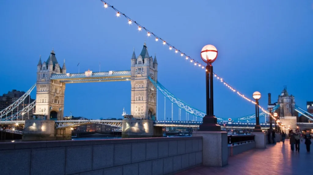
The eastern section culminates near Tower Bridge, a landmark completed in 1894 that remains one of London’s most recognisable engineering achievements.
To experience this historic landmark in person today, consult our comprehensive [The Evolution of the River Thames: London’s Lifeline Through the Centuries] for itineraries and visiting parameters.
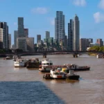
Why has the River Thames been central to the South Bank’s identity?
The River Thames shaped the South Bank’s economic, social, cultural, and physical development by serving as a transportation corridor, commercial artery, defensive boundary, and focal point for public life throughout London’s history.
No understanding of the South Bank is possible without understanding the Thames.
The river supported London’s emergence as a major trading centre. Goods entered and left the city through river-based transportation networks for centuries. Warehouses, docks, and markets developed in response to these commercial demands.
The Thames also influenced settlement patterns. Areas along the river attracted merchants, labourers, artisans, and entrepreneurs. This concentration of economic activity encouraged urban growth.
Bridges transformed interactions between the north and south sides of London. Structures such as Westminster Bridge, Blackfriars Bridge, Waterloo Bridge, and Tower Bridge improved connectivity and stimulated development.
The river additionally shaped cultural identity. Writers, artists, historians, and photographers frequently depicted the Thames as a symbol of London itself. The South Bank provides some of the city’s most iconic river views, making it a popular location for cultural interpretation and public events.
Environmental management also influenced development. Embankment projects, flood-control measures, and infrastructure improvements helped create the modern riverside pathways enjoyed by visitors today.
How did theatre and entertainment shape the South Bank?
The South Bank became a major entertainment district during the sixteenth and seventeenth centuries when theatres, playhouses, inns, and performance venues established the area as one of England’s most important cultural centres.
Entertainment has been integral to the South Bank for centuries.
In Elizabethan London, authorities often regulated activities within the City of London. Theatre operators therefore sought locations beyond municipal restrictions. Bankside emerged as an attractive destination.
Several prominent playhouses operated in the area. Examples include the Globe Theatre, the Rose Theatre, and the Swan Theatre. These venues contributed to the flourishing of English drama during the Renaissance.
William Shakespeare’s works were closely associated with the Globe Theatre. Performances attracted audiences from different social classes and helped establish London’s reputation as a cultural capital.
Entertainment on the South Bank extended beyond theatre. Animal-baiting arenas, public spectacles, fairs, and taverns drew large crowds. These activities reflected broader patterns of urban recreation during the early modern period.
Archaeological investigations have revealed remnants of historic playhouses and associated structures. Such discoveries continue to enhance understanding of London’s cultural history.
Modern institutions preserve this theatrical heritage. Shakespeare’s Globe recreates aspects of historical performance practice while introducing new audiences to early modern drama.
What architectural styles can visitors observe along the route?
The South Bank Walk showcases architectural styles ranging from medieval remnants and Victorian engineering to post-war modernism and contemporary design, creating a chronological visual record of London’s urban development.
Architecture represents one of the route’s most significant educational resources.
Victorian engineering is visible through bridges, railway infrastructure, and industrial-era structures. These buildings reflect nineteenth-century advances in construction techniques and transportation systems.
Post-war modernism plays a major role in defining the area’s appearance. The Southbank Centre and National Theatre exemplify architectural approaches associated with reconstruction efforts following the Second World War.
Industrial heritage remains visible through adaptive reuse projects. Tate Modern demonstrates how former industrial buildings can be repurposed for contemporary cultural functions.
Contemporary architecture contributes additional layers to the urban landscape. Recent developments incorporate modern materials, sustainability measures, and mixed-use planning principles.
Historic preservation efforts ensure that structures from different periods remain part of the cityscape. The coexistence of multiple architectural styles allows visitors to observe centuries of urban evolution within a relatively short walking distance.
How has preservation protected the South Bank’s heritage?
Heritage preservation initiatives have protected historic structures, archaeological remains, cultural institutions, and public spaces while balancing conservation objectives with the demands of modern urban development and tourism.
Preservation efforts operate at multiple levels along the South Bank.
Protected historic buildings receive legal safeguards through heritage designation systems. These protections help maintain architectural integrity while allowing appropriate adaptation.
Archaeological research plays a crucial role in preserving historical knowledge. Excavations have uncovered evidence relating to Roman settlements, medieval industries, and early modern entertainment venues.
Cultural institutions contribute to preservation through exhibitions, archives, and educational programmes. Museums and theatres frequently interpret historical themes connected to the area.
Urban planning policies seek to balance development with conservation. New construction projects often undergo review processes designed to protect significant views, landmarks, and heritage assets.
Public engagement strengthens preservation outcomes. Community groups, historians, educators, and heritage organisations participate in initiatives that promote awareness of local history.
These efforts ensure that the South Bank remains both a living urban environment and a valuable historical resource.
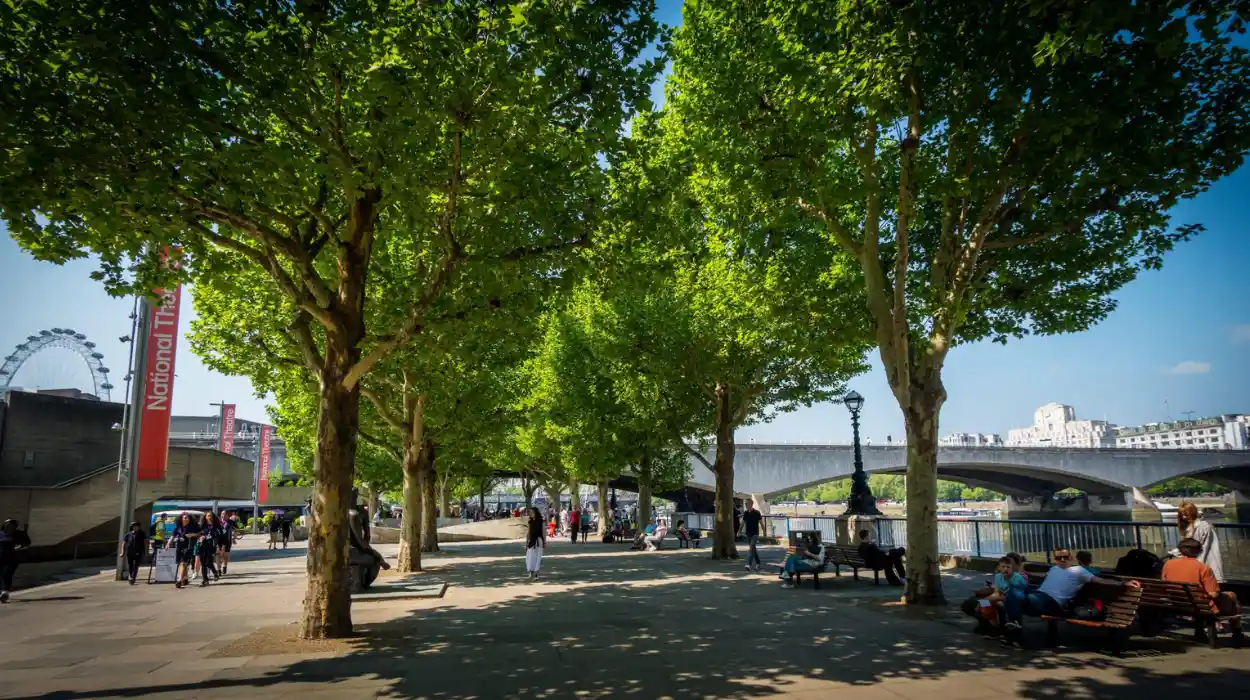
What makes the South Bank Walk one of London’s most scenic routes?
The South Bank Walk combines uninterrupted river views, iconic landmarks, historic bridges, public art, cultural venues, and accessible pedestrian spaces, creating a visually diverse environment that showcases London’s past and present simultaneously.
Scenic quality results from several interconnected factors.
The route offers extensive views of London’s skyline. Visitors can observe major landmarks positioned along both sides of the Thames, creating a constantly changing visual experience.
Bridges contribute significantly to the landscape. Examples include Westminster Bridge, Waterloo Bridge, Blackfriars Bridge, Millennium Bridge, and Tower Bridge. Each structure represents distinct engineering and architectural traditions.
Public spaces encourage engagement with the river environment. Promenades, terraces, and viewing areas provide opportunities for observation and photography.
Public art installations add cultural value to the walking experience. Rotating exhibitions and permanent works enhance visual interest throughout the year.
The absence of heavy road traffic along much of the riverside improves accessibility and pedestrian comfort. This design encourages exploration and supports recreational use.
Seasonal variation further enhances the route. Different lighting conditions, river levels, and cultural events continually reshape the visual character of the South Bank.
Why does the South Bank remain historically significant in the twenty-first century?
The South Bank remains historically significant because it preserves evidence of London’s evolution while continuing to function as a major centre for culture, education, tourism, and public engagement with the city’s heritage.
Historical significance is not limited to preserved buildings.
The South Bank illustrates how cities adapt over time. Roman activity, medieval entertainment, industrial expansion, post-war reconstruction, and modern regeneration are all represented within the same geographic corridor.
The area demonstrates the continuing influence of the River Thames on urban development. Economic, cultural, and social connections to the river remain visible in contemporary planning and public use.
Educational institutions and heritage organisations utilise the area as a living classroom. Students and researchers study architecture, archaeology, urban planning, transportation systems, and cultural history through direct observation.
Tourism generates widespread interest in London’s historical landscape. Millions of visitors encounter key aspects of British history through attractions located along the route.
Future preservation initiatives will continue to shape the South Bank’s role within London. As urban environments evolve, the area provides a model for integrating heritage conservation with modern public use.
The South Bank Walk therefore serves a dual function. It is both a recreational destination and a historical corridor that documents nearly two millennia of London’s development. Through its landmarks, architecture, cultural institutions, and relationship with the Thames, the route remains one of the clearest expressions of London’s past, present, and continuing evolution.
What is the South Bank Walk in London?
The South Bank Walk is a popular riverside pedestrian route along the southern bank of the River Thames, connecting major cultural, historical, and architectural landmarks in central London.