
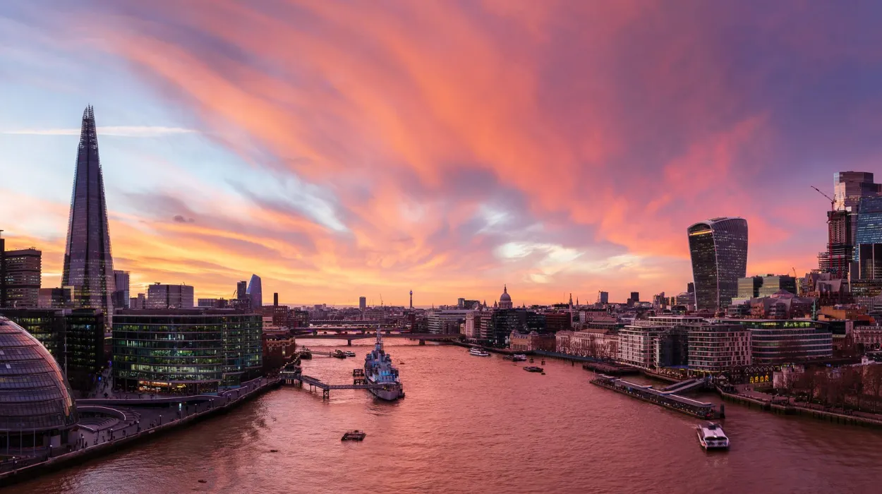
London’s skyline is a visual record of nearly two thousand years of political authority, economic expansion, technological innovation, destruction, and renewal. Every church spire, bridge, tower, dome, and skyscraper reflects a specific historical era that transformed Britain’s capital. From the Roman settlement of Londinium to the emergence of one of Europe’s largest financial centres, London’s skyline demonstrates how successive generations rebuilt the city while preserving many of its defining landmarks.
- Why is London’s skyline considered a living record of British history?
- How did Roman Londinium establish the foundations of London’s skyline?
- How did the medieval period transform London’s architectural identity?
- How did the Great Fire of London permanently reshape the city’s skyline?
- How did the Industrial Revolution alter London’s skyline during the nineteenth century?
- How did the Second World War change London’s skyline?
- How did modern skyscrapers redefine London’s skyline after the twentieth century?
- How have planning policies protected London’s historic skyline?
- What surviving landmarks best illustrate London’s historical skyline evolution?
- Why does London’s evolving skyline remain historically significant today?
Rather than developing according to a single master plan, London’s skyline evolved through conquest, devastating fires, industrialisation, war, planning regulations, engineering breakthroughs, and modern commercial investment. Medieval churches stand beside Victorian railway stations, twentieth-century civic buildings, and twenty-first-century glass towers, creating one of the world’s most recognisable urban landscapes.
This article explores the major historical events that reshaped London’s skyline and explains how each period left permanent architectural and cultural evidence that continues to define the city today.
Why is London’s skyline considered a living record of British history?
London’s skyline represents over 2,000 years of continuous urban development. Roman foundations, medieval churches, Tudor palaces, Georgian planning, Victorian engineering, post-war reconstruction, and modern skyscrapers collectively document Britain’s political, economic, religious, technological, and cultural transformation through successive historical periods.
Unlike cities rebuilt almost entirely after conflict or disaster, London retains significant architecture from numerous historical eras. This continuity allows historians to trace Britain’s evolution through its buildings.
The skyline reflects changing centres of power. Roman walls demonstrated imperial authority. Medieval cathedrals represented religious influence. Royal palaces symbolised monarchy. Victorian railway stations displayed industrial strength. Modern commercial towers illustrate London’s role as an international financial centre.
Architectural diversity also reflects changing construction technologies. Roman masonry, medieval stone craftsmanship, Georgian brick terraces, Victorian steel engineering, reinforced concrete, and contemporary high-performance glass all appear within the same urban landscape.
Government planning policies also shaped the skyline. Protected sightlines preserve views of St Paul’s Cathedral, while designated conservation areas safeguard historic districts. Modern planning therefore balances economic development with heritage protection.
Today, London’s skyline serves historians, architects, archaeologists, educators, and cultural visitors as a visible timeline of Britain’s national development.
How did Roman Londinium establish the foundations of London’s skyline?
Roman Londinium established London’s first organised urban landscape between AD 43 and AD 410. Defensive walls, administrative buildings, forums, temples, bridges, and engineered streets created the city’s earliest skyline and determined the urban framework influencing later development for centuries.
Roman Emperor Claudius ordered the invasion of Britain in AD 43. Soon afterwards, Londinium emerged on the north bank of the River Thames as an administrative and commercial settlement.
Roman engineers introduced systematic urban planning. Straight roads connected marketplaces, military facilities, public baths, and government buildings. Stone construction replaced temporary wooden structures.
The Forum and Basilica became the city’s political centre. These monumental buildings dominated Roman Londinium and reflected imperial administration across Britain.
The first London Bridge created a permanent crossing over the River Thames. This bridge encouraged trade and established London’s importance as a transport hub.
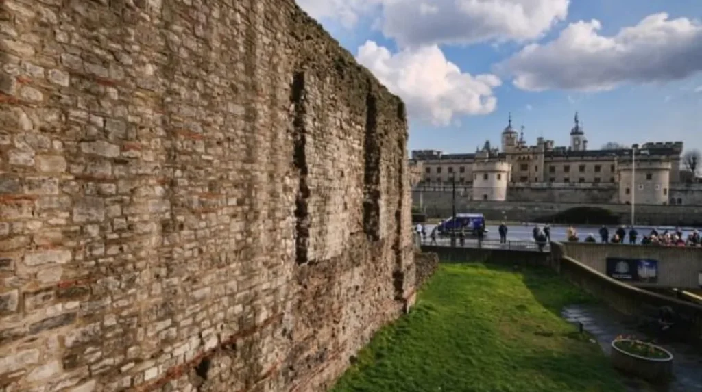
Around AD 200, defensive walls enclosed approximately 330 acres of urban development. Portions of the Roman Wall remain visible today near Tower Hill and the Barbican, providing archaeological evidence of the city’s earliest skyline.
Although few Roman buildings survive above ground, modern archaeological excavations continue revealing foundations beneath contemporary office developments, demonstrating the remarkable continuity of London’s urban geography.
How did the medieval period transform London’s architectural identity?
The medieval period replaced Roman civic architecture with religious, commercial, and defensive landmarks. Churches, monasteries, guild halls, castles, markets, and bridges dominated London’s skyline between the eleventh and fifteenth centuries while supporting expanding trade and royal government.
Following the Norman Conquest of 1066, William the Conqueror strengthened royal authority by constructing the Tower of London. Its White Tower became one of medieval Europe’s most formidable defensive structures and remains among London’s oldest surviving skyline landmarks.
Church construction accelerated dramatically during the medieval era. Hundreds of parish churches emerged across the growing city, their stone towers and spires becoming the most prominent features visible from surrounding countryside.
Old St Paul’s Cathedral, completed during the Middle Ages, featured one of Europe’s tallest church spires before its destruction in the seventeenth century.
Guild halls reflected London’s expanding commercial economy. Merchant associations financed substantial civic buildings that demonstrated growing urban wealth.
London Bridge also evolved into a unique urban landmark. Houses, chapels, and shops lined the bridge, transforming it into a densely populated commercial street crossing the Thames.
Markets expanded around Cheapside, Smithfield, and Billingsgate, reinforcing London’s importance as England’s leading trading city.
The medieval skyline therefore reflected the close relationship between monarchy, religion, commerce, and civic governance.
How did the Great Fire of London permanently reshape the city’s skyline?
The Great Fire of 1666 destroyed approximately 13,200 houses, 87 parish churches, major civic buildings, and Old St Paul’s Cathedral. Reconstruction introduced fire-resistant architecture, wider streets, and landmark buildings that permanently transformed London’s appearance.
The Great Fire began on 2 September 1666 in Pudding Lane and spread rapidly through densely packed timber buildings.
Within four days, much of the medieval City of London had been destroyed.
Reconstruction represented one of Europe’s largest urban rebuilding programmes.
Architect Christopher Wren became the central figure in London’s architectural recovery. His most significant achievement was the new St Paul’s Cathedral, completed in 1710. Its magnificent dome dominated London’s skyline for over 250 years and became a national symbol.
Wren also designed or rebuilt more than fifty parish churches, introducing elegant towers and distinctive spires that remain visible across the Square Mile.
Building regulations required brick and stone construction instead of timber. Streets became wider to reduce future fire risk and improve movement throughout the city.
Although several ambitious grid plans were proposed, property ownership complexities prevented complete redesign. Consequently, London’s medieval street pattern largely survived beneath its new architecture.
The Great Fire therefore reshaped London’s skyline without erasing its historic urban framework.
To experience this historic landmark in person today, consult our comprehensive [Best London Viewpoints for Capturing Stunning City Skylines and Iconic Landmark Photography] for itineraries and visiting parameters.
How did the Industrial Revolution alter London’s skyline during the nineteenth century?
Industrialisation transformed London’s skyline through railways, bridges, factories, warehouses, docks, public institutions, and engineering landmarks. Rapid population growth and technological innovation expanded the city while introducing entirely new architectural forms between 1800 and 1900.
London’s population increased from approximately one million in 1800 to over six million by the beginning of the twentieth century.
Railway construction represented the most significant physical transformation. Major stations including Paddington, King’s Cross, St Pancras, Liverpool Street, Waterloo, and Victoria introduced enormous iron-and-glass train sheds unlike previous architecture.
Victorian engineers also expanded London’s bridges. New crossings improved transportation while contributing distinctive visual landmarks across the River Thames.
Docklands grew into one of the world’s busiest port systems. Warehouses, cranes, docks, and shipping infrastructure extended eastwards, reflecting Britain’s expanding global trade.
Factories appeared throughout industrial districts, accompanied by tall chimneys that altered London’s skyline for the first time through industrial rather than religious architecture.
Public institutions also expanded. Museums, libraries, universities, hospitals, and government buildings demonstrated Victorian confidence in education, science, and civic administration.
Engineering innovation allowed increasingly ambitious structures using cast iron, wrought iron, steel, and improved brick manufacturing.
The nineteenth century therefore shifted London’s skyline from predominantly ecclesiastical buildings towards commercial, industrial, and transportation infrastructure.
How did the Second World War change London’s skyline?
The Second World War caused widespread destruction during the Blitz between 1940 and 1941. Bombing damaged thousands of buildings, creating opportunities for post-war reconstruction while preserving many nationally significant historic landmarks through extensive protection efforts.
German bombing campaigns targeted London’s docks, transport infrastructure, industries, and administrative districts.
Thousands of buildings suffered severe damage. Entire streets disappeared across the East End and central London.
Despite intense bombing, several nationally important landmarks survived, including St Paul’s Cathedral. Images of the cathedral’s dome rising above smoke became powerful symbols of national resilience.
After the war, extensive rebuilding programmes addressed severe housing shortages while modernising damaged infrastructure.
Architects increasingly adopted reinforced concrete construction. Modern office buildings gradually replaced bomb-damaged Victorian commercial properties.
New housing estates reflected changing planning philosophies prioritising improved sanitation, green spaces, and higher residential density.
Some historic buildings underwent meticulous restoration rather than replacement, demonstrating growing commitment to architectural conservation.
The Second World War therefore produced both substantial architectural loss and significant opportunities for urban modernisation.
How did modern skyscrapers redefine London’s skyline after the twentieth century?
Modern skyscrapers introduced vertical commercial development while maintaining historic sightlines through planning regulation. Financial expansion, engineering advances, and international investment created a globally recognised skyline featuring contemporary towers alongside protected historic landmarks.
During the late twentieth century, London’s economy shifted increasingly toward finance, professional services, technology, and international business.
Demand for premium office space encouraged taller buildings, particularly within the City of London and Canary Wharf.
Engineering developments enabled safer and more efficient skyscraper construction through advanced steel frames, reinforced concrete cores, energy-efficient glazing, and sophisticated structural systems.
Landmarks such as The Gherkin, The Shard, The Cheesegrater, The Walkie Talkie, and the Scalpel introduced internationally recognised contemporary architecture.
Planning authorities carefully regulated development through protected viewing corridors. Strategic sightlines preserve uninterrupted views of St Paul’s Cathedral from numerous public locations across London.
Developers therefore design new towers around existing heritage protections rather than replacing historic landmarks.
Modern architecture now complements rather than overwhelms London’s historic skyline, creating visual contrast between centuries of architectural evolution.
This balanced approach distinguishes London from many rapidly modernised global cities.
How have planning policies protected London’s historic skyline?
Planning regulations preserve London’s historic identity by protecting landmark views, conservation areas, listed buildings, archaeological remains, and heritage settings while allowing carefully managed commercial development in designated locations across the capital.
Historic preservation became increasingly important during the twentieth century.
The listing system legally protects architecturally or historically significant buildings from inappropriate alteration or demolition.
Conservation areas safeguard historic neighbourhoods rather than individual structures alone. These areas preserve distinctive streetscapes developed across different historical periods.
Protected viewing corridors remain among London’s most influential planning tools. They ensure important landmarks remain visible despite ongoing commercial construction.
Archaeological planning policies require developers to investigate buried remains before construction begins. Significant discoveries often reshape development proposals.
Local authorities work alongside Historic England and other heritage organisations to balance conservation with economic growth.
These planning mechanisms explain why Roman remains, medieval churches, Georgian terraces, Victorian institutions, and contemporary skyscrapers coexist within the same city.
The skyline therefore reflects deliberate long-term management rather than uncontrolled urban expansion.
What surviving landmarks best illustrate London’s historical skyline evolution?
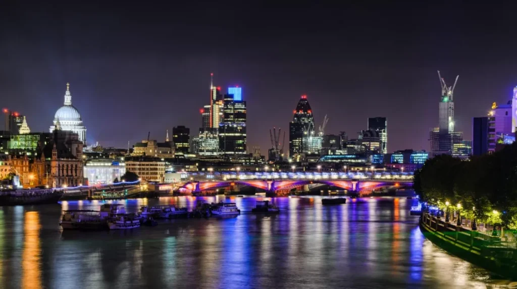
London’s surviving landmarks collectively represent successive historical periods. Roman walls, medieval fortifications, seventeenth-century churches, Victorian engineering, twentieth-century civic buildings, and modern skyscrapers provide continuous physical evidence of Britain’s architectural and historical development.
Several landmarks demonstrate remarkable historical continuity.
The Tower of London preserves Norman military architecture dating from the eleventh century.
St Paul’s Cathedral represents the architectural achievements of post-Great Fire reconstruction.
The Palace of Westminster illustrates nineteenth-century Gothic Revival architecture following reconstruction after the 1834 parliamentary fire.
Tower Bridge showcases Victorian engineering and industrial innovation.
Canary Wharf reflects London’s transformation into a leading international financial centre during the late twentieth century.
The Shard symbolises twenty-first-century architectural ambition and advanced engineering techniques.
Meanwhile, surviving Roman walls continue reminding visitors that London’s modern skyline rests upon foundations established nearly two millennia ago.
Together, these landmarks provide an uninterrupted architectural narrative rarely matched by other global capitals.
Why does London’s evolving skyline remain historically significant today?
London’s skyline remains historically significant because it demonstrates continuous adaptation across nearly two thousand years. Successive generations preserved important landmarks while embracing technological innovation, enabling the city to balance heritage conservation with modern economic and architectural development.
The skyline represents more than architectural diversity. It records Britain’s political evolution, commercial expansion, religious history, industrialisation, wartime resilience, and global influence.
Each historical era contributed distinctive structures rather than completely replacing earlier development. This layered approach allows historians to interpret London’s past through surviving buildings.
Archaeological discoveries continue expanding understanding of Roman and medieval London beneath modern streets. Heritage conservation ensures these findings influence future planning decisions.
Contemporary sustainability initiatives increasingly guide new construction. Energy-efficient skyscrapers, adaptive reuse of historic buildings, and environmentally responsible planning demonstrate how London’s skyline continues evolving while respecting its historical foundations.
For educators, the skyline provides an accessible visual chronology of British history. For cultural tourists, it offers one of the world’s richest collections of architectural heritage within a single metropolitan landscape. For researchers, it preserves evidence of changing political authority, engineering capability, social organisation, and economic priorities across almost twenty centuries.
London’s skyline therefore remains both a historical archive and a living urban environment. Every major transformation—from Roman occupation and medieval expansion to the Great Fire, Industrial Revolution, wartime reconstruction, and modern commercial development—left visible evidence that continues to define the capital today. As new buildings rise alongside protected landmarks, the skyline continues documenting the next chapter in London’s long and remarkable historical story.
How did Roman Londinium influence London’s skyline?
Roman Londinium introduced planned streets, defensive walls, bridges, forums, and public buildings, establishing the urban layout that influenced London’s growth for centuries.