London’s skyline represents more than architectural beauty. It records nearly 2,000 years of urban development, from Roman foundations to medieval churches, Victorian engineering, post-war reconstruction, and contemporary skyscrapers. Every viewpoint across the capital reveals a different chapter of London’s history, showing how political authority, commerce, religion, engineering, and cultural identity have shaped one of the world’s most recognisable cityscapes.
- Why are London’s viewpoints historically significant?
- How did London’s skyline evolve through history?
- Which viewpoints provide the most complete panorama of London’s skyline?
- Why does the River Thames create London’s most iconic photographic perspectives?
- How do protected viewing corridors preserve London’s historic skyline?
- Which landmarks dominate London’s skyline and why?
- How have photography and art influenced London’s famous viewpoints?
- What seasonal and environmental factors shape London’s skyline photography?
- How are London’s viewpoints preserved for future generations?
- Why do London’s viewpoints remain culturally and historically important?
The city’s protected viewing corridors, historic hills, riverside promenades, observation platforms, and public parks preserve important perspectives that have inspired artists, architects, historians, and photographers for centuries. Many viewpoints also illustrate how planning regulations have balanced modern development with the preservation of nationally significant landmarks such as St Paul’s Cathedral, the Palace of Westminster, and the Tower of London.
For photographers, cultural tourists, educators, and history enthusiasts, London’s viewpoints provide both visual excellence and historical interpretation. Understanding why these locations exist, how they developed, and what they reveal about London’s evolution adds historical depth beyond simply taking photographs.
Why are London’s viewpoints historically significant?
London’s viewpoints preserve centuries of urban development, document architectural change, protect nationally important sightlines, and reveal how geography, politics, engineering, and planning shaped the capital. They provide visual records of London’s transformation from a Roman settlement into a global metropolis while maintaining protected perspectives of iconic landmarks.
Unlike many major cities, London’s skyline developed gradually across nearly two millennia. Each generation added new buildings while preserving earlier monuments. From elevated hills formed during the Ice Age to carefully protected observation terraces, London’s viewpoints reveal this layered history.
Several viewpoints originated naturally. Hills such as Parliament Hill and Greenwich Park provided strategic defensive positions long before photography existed. During medieval England, elevated ground allowed early communities to monitor trade routes and approaching travellers.
The River Thames also shaped London’s visual identity. Its sweeping curves create constantly changing perspectives that reveal different combinations of bridges, churches, commercial districts, and modern skyscrapers.
Today, London’s planning policies protect numerous historic viewing corridors. These regulations prevent new developments from obstructing important views towards nationally significant buildings, particularly St Paul’s Cathedral.
How did London’s skyline evolve through history?
London’s skyline evolved through Roman construction, medieval religious expansion, Tudor political centralisation, Victorian industrialisation, post-war rebuilding, and twenty-first-century commercial development. Each period introduced distinctive structures that remain visible from the city’s principal viewpoints and collectively define London’s architectural identity.
The earliest skyline emerged after the Romans established Londinium around AD 47. Defensive walls, forums, basilicas, and riverside warehouses dominated the settlement.
Following the Norman Conquest in 1066, monumental stone buildings transformed London’s appearance. The White Tower became both a military fortress and a symbol of royal authority.
During the medieval period, hundreds of parish churches and monasteries introduced church spires that dominated London’s skyline. Before the sixteenth century, religious buildings represented the city’s tallest structures.
The Great Fire of London in 1666 destroyed approximately 13,200 houses, 87 parish churches, and many civic buildings across the medieval city. The rebuilding programme led by Sir Christopher Wren introduced a more ordered skyline centred on St Paul’s Cathedral, completed in 1710.
The nineteenth century dramatically expanded London’s skyline. Railway stations, bridges, warehouses, government buildings, and commercial offices reflected Britain’s Industrial Revolution. Engineering achievements such as Tower Bridge demonstrated Victorian technological innovation.
After the Second World War, reconstruction replaced bomb-damaged districts with modern developments. From the late twentieth century onwards, commercial skyscrapers such as The Shard, 30 St Mary Axe, and the City of London financial district reshaped London’s silhouette while protected sightlines preserved historic landmarks.
Which viewpoints provide the most complete panorama of London’s skyline?
Several historic hills, public parks, riverside locations, and observation platforms provide comprehensive panoramic views. These viewpoints combine geographical elevation with historical significance, allowing visitors to observe London’s architectural evolution across multiple centuries from carefully preserved public spaces.
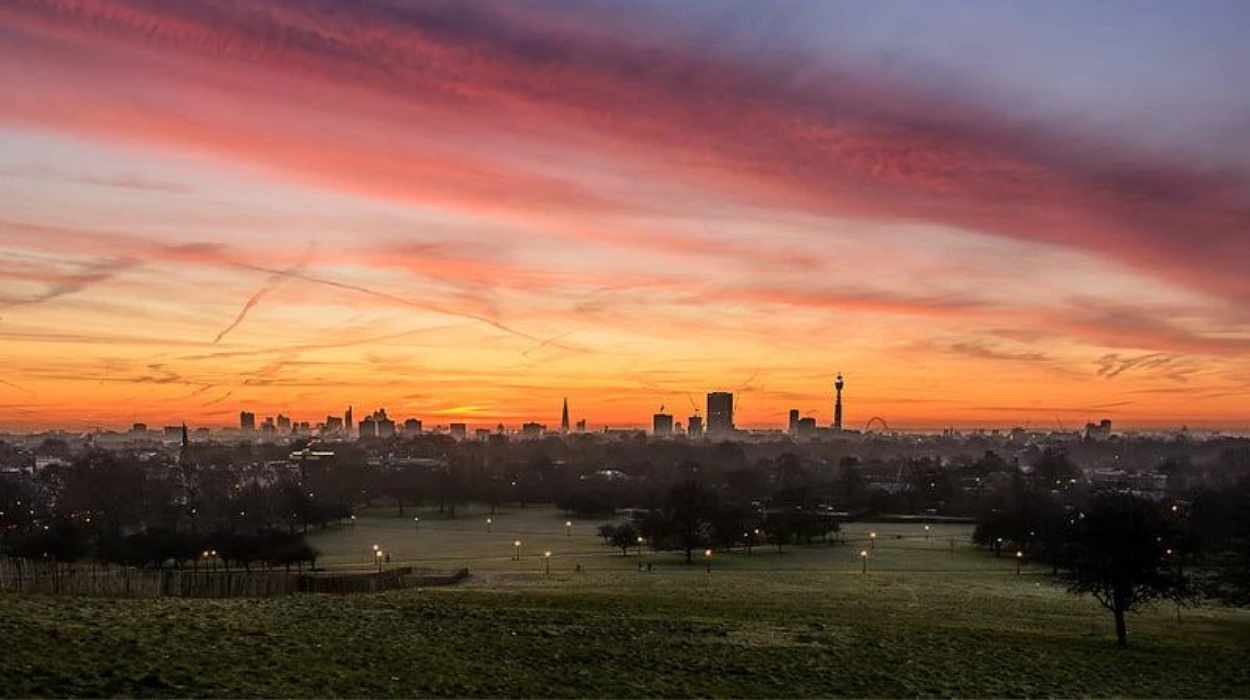
Primrose Hill
Primrose Hill rises approximately 63 metres above sea level within Regent’s Park. Since the nineteenth century, it has offered one of London’s most celebrated panoramic views.
From its summit, photographers capture St Paul’s Cathedral, The Shard, the City of London, Canary Wharf, and Westminster within a single sweeping composition.
The hill became protected public land in the 1840s following campaigns to preserve open space for London’s expanding population.
Parliament Hill
Located within Hampstead Heath, Parliament Hill reaches approximately 98 metres above sea level.
Historical records indicate the hill served strategic purposes during the English Civil War. Today, it provides one of London’s widest uninterrupted skyline panoramas.
The view extends across central London, allowing observers to distinguish historical districts from modern financial developments.
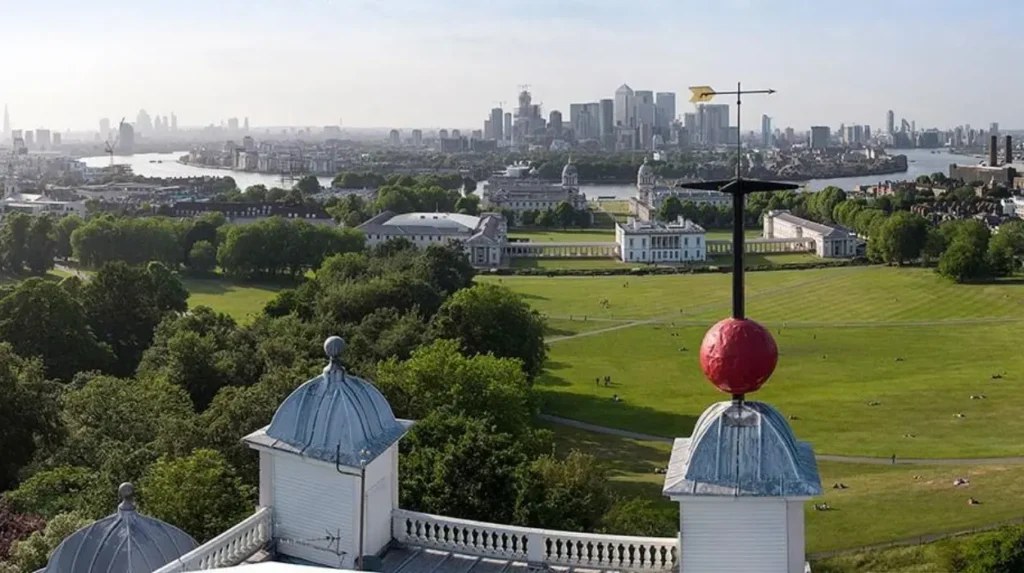
Greenwich Park
Greenwich Park combines historical significance with exceptional photographic opportunities.
Originally enclosed by Henry VIII during the sixteenth century, the park surrounds the Royal Observatory and overlooks the River Thames.
The elevated viewpoint captures Canary Wharf, the Old Royal Naval College, maritime heritage buildings, and central London’s distant skyline.
Alexandra Palace
Completed in 1873, Alexandra Palace stands on one of North London’s highest points.
Its elevated terrace reveals extensive views extending over central London while demonstrating how suburban development expanded during the Victorian era.
Sky Garden
Located within the “Walkie Talkie” building, Sky Garden offers one of London’s highest publicly accessible indoor viewpoints.
Its elevated position enables photographers to observe protected viewing corridors and appreciate how modern skyscrapers integrate with historic districts.
To experience these historic landmarks in person today, consult our comprehensive [How London’s Skyline Changed Through Major Historical Events and Modern Development] for itineraries and visiting parameters.
Why does the River Thames create London’s most iconic photographic perspectives?
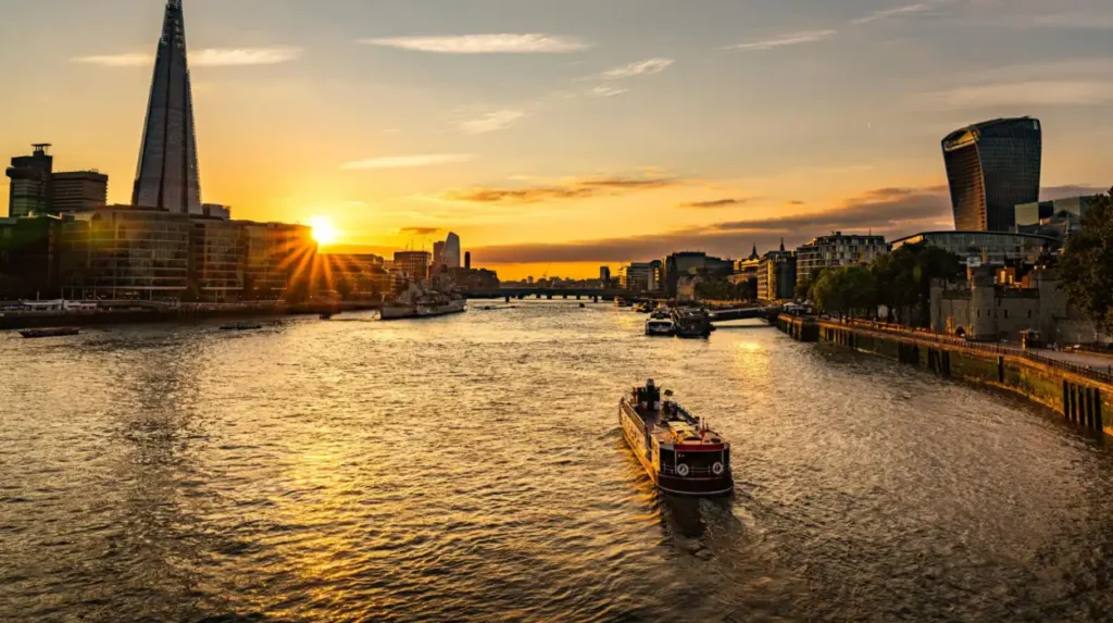
The River Thames shapes London’s skyline by providing uninterrupted sightlines between historic landmarks, bridges, government buildings, and commercial districts. Its curved course naturally frames architectural compositions that illustrate London’s political, economic, and cultural development across nearly twenty centuries.
The Thames remains London’s defining geographical feature.
Roman Londinium developed beside its northern bank because the river supported trade, transportation, and military logistics.
Throughout the medieval and early modern periods, bridges connected expanding communities while riverside wharves handled goods arriving from across Britain and the wider world.
Photographic viewpoints along the Thames reveal multiple historic landmarks within single compositions.
Westminster Bridge frames the Palace of Westminster alongside Elizabeth Tower.
Waterloo Bridge offers broad views toward St Paul’s Cathedral, Somerset House, and the City of London.
Tower Bridge provides perspectives incorporating the Tower of London, modern financial towers, and historic docklands.
South Bank promenades also demonstrate London’s successful regeneration. Former industrial areas now contain museums, theatres, galleries, and public spaces while preserving historic riverfront access.
How do protected viewing corridors preserve London’s historic skyline?
Protected viewing corridors are legally designated sightlines that prevent inappropriate development from obstructing nationally significant landmarks. Established through planning policy, these protected views preserve London’s historic identity while allowing carefully managed urban growth and architectural innovation.
London operates one of the world’s most sophisticated skyline protection systems.
Protected views originated during concerns that increasingly tall buildings would obscure St Paul’s Cathedral and other nationally important monuments.
The London View Management Framework identifies strategic viewing locations and establishes planning guidance governing nearby developments.
Developers proposing tall buildings must demonstrate that projects preserve protected sightlines.
Examples include views from Richmond Park, Greenwich Park, Primrose Hill, King Henry VIII’s Mound, and Parliament Hill.
These planning controls allow London’s skyline to evolve without erasing historically significant visual relationships.
The framework represents an internationally recognised model for balancing heritage conservation with economic development.
Which landmarks dominate London’s skyline and why?
London’s skyline features landmarks representing monarchy, religion, commerce, government, transportation, and engineering. These structures achieved prominence through historical importance, architectural innovation, symbolic authority, or exceptional height, making them enduring focal points in panoramic photography.
St Paul’s Cathedral
Completed in 1710 after the Great Fire of London, St Paul’s Cathedral became London’s dominant architectural landmark.
Its dome rises approximately 111 metres, intentionally matching the traditional limit of ecclesiastical symbolism.
For more than 250 years, no London building surpassed its height.
Palace of Westminster
Following the devastating fire of 1834, architect Charles Barry and Augustus Pugin designed the current Gothic Revival parliamentary complex.
Elizabeth Tower, commonly associated with the Great Bell known as Big Ben, became an internationally recognised symbol of British democracy.
Tower Bridge
Completed in 1894, Tower Bridge combined suspension bridge engineering with Gothic-inspired architecture.
Its distinctive towers remain among London’s most photographed structures.
The Shard
Completed in 2012, The Shard reaches approximately 310 metres.
Designed by architect Renzo Piano, it became the United Kingdom’s tallest building and introduced a contemporary vertical landmark visible across much of Greater London.
The Gherkin
Officially known as 30 St Mary Axe, the building opened in 2004.
Its energy-efficient curved design transformed perceptions of London’s modern financial district while complementing protected historical views.
How have photography and art influenced London’s famous viewpoints?
Artists and photographers documented London’s viewpoints for centuries, transforming elevated locations and riverside perspectives into internationally recognised cultural symbols. Their work preserved historical landscapes, recorded architectural change, and established visual traditions that continue influencing tourism, education, and heritage interpretation.
Before photography, painters documented London’s skyline through engravings, watercolours, and oil paintings.
Canaletto’s eighteenth-century cityscapes accurately recorded riverside architecture and commercial activity.
During the Victorian era, photography emerged as a powerful documentary tool.
Early photographers captured bridges, markets, railway stations, churches, and expanding suburbs.
Following wartime bombing during the Second World War, photographers documented destruction alongside reconstruction.
Their images now provide valuable historical records for researchers studying urban development.
Modern digital photography continues this tradition by recording ongoing changes within London’s skyline while encouraging public appreciation of architectural heritage.
What seasonal and environmental factors shape London’s skyline photography?
Natural light, weather patterns, atmospheric conditions, and seasonal changes significantly influence London’s skyline appearance. These environmental factors alter visibility, colour, shadow, and reflections, creating historically documented variations that photographers have studied and utilised for generations.
London experiences approximately 1,500 hours of sunshine annually.
Spring offers clearer atmospheric conditions following winter rainfall.
Summer provides extended daylight suitable for panoramic photography.
Autumn introduces warmer colours across historic parks including Greenwich Park, Richmond Park, and Hampstead Heath.
Winter produces crisp visibility after cold weather fronts while creating dramatic sunrise and sunset conditions.
Fog historically played an important role in London’s visual identity.
Before twentieth-century clean air legislation, coal smoke frequently combined with natural mist to produce dense “pea-souper” fogs.
Following the Clean Air Acts introduced after the Great Smog of 1952, visibility improved substantially, allowing clearer skyline photography throughout much of the year.
How are London’s viewpoints preserved for future generations?
Government agencies, conservation organisations, planning authorities, and heritage professionals preserve London’s viewpoints through environmental protection, planning regulations, landscape management, and heritage conservation. These coordinated efforts safeguard both physical viewpoints and the historic skylines visible from them.
Historic England, local authorities, and the Greater London Authority collaborate to protect London’s visual heritage.
Regular landscape maintenance preserves vegetation without obstructing historically significant sightlines.
Planning authorities evaluate major construction projects against protected view requirements before granting approval.
Historic parks receive ongoing conservation funding that maintains pathways, terraces, observation points, and landscape features.
UNESCO World Heritage Sites, including Maritime Greenwich and the Tower of London, receive additional international recognition supporting skyline preservation.
Technological advances also strengthen conservation.
Three-dimensional modelling enables planners to evaluate proposed developments before construction begins.
Digital archives preserve historical photographs, allowing researchers to compare skyline evolution across decades.
Educational institutions increasingly use these records to teach urban planning, architectural history, and heritage conservation.
Why do London’s viewpoints remain culturally and historically important?
London’s viewpoints connect geography, architecture, politics, history, and public memory. They preserve visual evidence of nearly two thousand years of continuous urban development while supporting education, tourism, heritage conservation, and public appreciation of one of the world’s most historically significant city skylines.
Every major viewpoint reveals multiple historical periods simultaneously.
A single panorama often includes Roman foundations, Norman fortifications, medieval churches, Georgian planning, Victorian engineering, twentieth-century reconstruction, and contemporary skyscrapers.
This layered visibility distinguishes London from many global cities whose skylines developed over shorter periods.
The viewpoints also strengthen historical interpretation.
Students examine architectural styles within their geographical context.
Researchers compare historical photographs to evaluate urban change.
Tourists gain a deeper understanding of London’s development beyond individual landmarks.
For photographers, these locations provide enduring opportunities to document a city that continues evolving while preserving its defining historical identity.
As London grows, its protected viewpoints remain essential public assets. They demonstrate that heritage preservation and modern development are compatible when guided by thoughtful planning, historical understanding, and long-term stewardship. Together, these remarkable vantage points ensure future generations will continue experiencing one of the world’s most recognisable and historically significant urban skylines.
What is the best viewpoint for seeing London’s skyline?
Some of the best viewpoints include Primrose Hill, Parliament Hill, Greenwich Park, Sky Garden, and Alexandra Palace. Each offers a unique perspective of London’s historic landmarks and modern skyline.