Notting Hill is one of London’s best-known neighbourhoods, but its present identity developed through several distinct historical phases. The area changed from rural fields and gravel pits into a Victorian suburb, then into a working-class district, a Caribbean cultural centre, a market destination, and a high-value residential area.
- What was Notting Hill like before it became a London suburb?
- When did Notting Hill begin changing into a residential district?
- How did the Ladbroke Estate shape Notting Hill’s architecture?
- How did railways and transport change Notting Hill?
- Why did Portobello Road become central to Notting Hill’s identity?
- How did immigration transform Notting Hill’s social history?
- How did the Notting Hill Carnival change the neighbourhood’s cultural identity?
- How did Notting Hill change during the post-war decades?
- When did Notting Hill become an expensive and highly desirable neighbourhood?
- Which historic buildings and landscapes still survive in Notting Hill?
- How did Notting Hill’s historic identity influence tourism and popular culture?
- How has preservation shaped Notting Hill’s modern identity?
- How did Grenfell Tower become part of Notting Hill’s modern history?
- Why is Notting Hill considered one of London’s most iconic neighbourhoods?
- Frequently Asked Question
Its history is closely connected with Kensington, North Kensington, Paddington, Westbourne Grove, Ladbroke Grove and Notting Hill Gate. Roads, railways, housing estates, markets, migration and conservation policies all shaped the physical and social character visible today.
The neighbourhood also contains an important archaeological record. Historic England identifies the wider Kensington area as part of an ancient landscape crossed by Roman routes. Extensive gravel and brickearth extraction later altered the ground, while archaeological discoveries made during nineteenth-century development provide evidence of earlier settlement and burial activity.
Notting Hill’s transformation therefore was not a single event. It was a long process that accelerated particularly between the early nineteenth century and the twentieth century.
What was Notting Hill like before it became a London suburb?
Before nineteenth-century urbanisation, Notting Hill consisted largely of open land, agricultural uses, gravel extraction and scattered settlements west of central London, with Roman roads providing important routes across the wider landscape before large-scale residential construction.
The landscape around Notting Hill was very different from the densely built neighbourhood seen today. Historic England records that the area was known as Kensington Gravel Pits during the post-medieval period because gravel and brickearth were extracted extensively from the local ground. These materials were important to London’s expanding construction industry.
The archaeological background reaches much further back. The London-to-Silchester Roman road passed through the wider area and formed an important communication route between Roman London and settlements to the west. The route helped establish the long-term importance of the corridor now associated with Notting Hill Gate and Kensington.
Later quarrying changed the landscape substantially. Gravel extraction created hollows and altered the buried archaeological environment. Brickearth was also valuable for manufacturing bricks as London expanded.
By the eighteenth century, the area remained substantially less urban than central London. Kensington itself was developing as a fashionable settlement, while the land farther west and north retained open spaces, gardens, fields and industrial activities.
This geographical position became important during the nineteenth century. London was expanding rapidly, and land beyond established central districts became increasingly attractive for residential development.
Notting Hill therefore stood at the intersection of two forces: the preservation of an older semi-rural landscape and the rapid outward growth of metropolitan London.
When did Notting Hill begin changing into a residential district?
Notting Hill’s major residential transformation began during the early nineteenth century and accelerated between about 1820 and 1880, when estates, roads and terraces replaced fields and industrial land and connected the district more closely with expanding London.
Historic England identifies the period from 1820 to 1880 as a decisive phase in the transformation of the Notting Hill landscape. Development began on estates including Norland and the Ladbroke Estate after the closure of the short-lived Hippodrome racecourse.
The Hippodrome was established in 1836 as a horse-racing venue and closed in 1842. Its failure created an opportunity for a different form of land use. Residential development subsequently became the dominant force across the Ladbroke Estate.
The Ladbroke Estate produced one of the most recognisable physical features of modern Notting Hill: broad streets arranged around communal garden squares.
The development reflected nineteenth-century ideas about suburban housing. Builders created terraces with repeated architectural details, private entrances and access to landscaped communal spaces. The layout provided relatively spacious housing while maintaining a planned urban form.
The area’s architecture was also connected to changing social patterns. As London’s population expanded, new suburban districts accommodated residents moving away from increasingly crowded central areas.
The transformation was not uniform. North Kensington developed with a different economic and industrial character. The Royal Borough of Kensington and Chelsea records that early nineteenth-century North Kensington contained potteries and piggeries, with brickmaking linked to local clay extraction. Pottery Lane took its name from these activities.
This distinction became significant. The southern parts around Ladbroke Square, Pembridge and Westbourne Grove developed extensive middle-class residential architecture, while areas farther north developed more mixed industrial and working-class communities.
The foundations of modern Notting Hill were therefore established through contrasting forms of development.
How did the Ladbroke Estate shape Notting Hill’s architecture?
The Ladbroke Estate established a distinctive residential landscape of Victorian terraces, crescents, garden squares and planned streets, creating the architectural framework that remains one of Notting Hill’s strongest historical characteristics today.
The Ladbroke Estate is central to understanding the neighbourhood’s physical identity. Its development created terraces arranged around large communal gardens, including Ladbroke Square and associated streets.
The architecture reflects nineteenth-century speculative development. Developers constructed repeated rows of houses using broadly consistent designs while adapting individual buildings to corners, crescents and prominent positions.
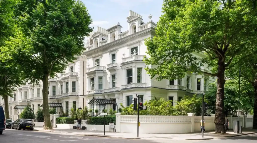
The resulting streetscape contains stuccoed façades, classical detailing, terraces, bay windows, balconies and enclosed private spaces. Many buildings were constructed during the Victorian period, although later alterations introduced additional architectural styles.
The present Ladbroke Conservation Area reflects this historical development. The Royal Borough of Kensington and Chelsea describes the conservation area as predominantly nineteenth-century development containing Victorian and Edwardian architecture. Its conservation appraisal was adopted in 2015.
The surviving architecture demonstrates how land ownership and speculative construction influenced London’s suburban expansion. Estate development established street patterns that later transport infrastructure and commercial activity built upon rather than completely replacing.
The garden squares are especially important. They formed planned open spaces within dense residential development and remain defining elements of the neighbourhood.
Notting Hill’s architecture therefore became historic not simply because individual houses survived, but because large sections of the nineteenth-century urban plan remain legible.
The survival of terraces, gardens, crescents and street alignments allows historians to reconstruct the development process directly from the built environment.
How did railways and transport change Notting Hill?
Railways and improved roads connected Notting Hill with central London and surrounding districts, accelerating housing development, population growth, commerce and industrial activity while turning a peripheral landscape into an integrated part of the expanding metropolitan city.
Transport infrastructure transformed the economic geography of the area.
The Great Western Railway was formed in 1837, helping stimulate development farther west and north. The railway contributed to the growth of Kensal Green and Kensal New Town, while Portobello Road provided an important route connecting communities with Notting Hill.
The development of the railway network made suburban living increasingly practical. Residents could live farther from central London while retaining access to employment and commercial districts.
The transport system also supported industrial activity. By 1874, the Great Western Railway, Hammersmith and City line and West London Railway had been constructed in the wider area.
Notting Hill Gate had an older transport history. Until 1864, a turnpike toll gate stood there on the Roman road leading west from London. Turnpikes were systems in which travellers paid tolls for the maintenance and improvement of designated roads.
The disappearance of the toll gate reflected broader changes in London’s transport administration and urban growth.
Later Underground connections strengthened Notting Hill’s metropolitan role. The Central, District and Circle lines provided connections across London, while roads such as Holland Park Avenue and the route through Notting Hill Gate became major transport corridors.
Transport did not simply bring visitors. It changed land values, employment patterns, retail activity and the pace of construction.
The result was a neighbourhood that increasingly functioned as part of metropolitan London rather than as a peripheral settlement.
Why did Portobello Road become central to Notting Hill’s identity?
Portobello Road became central to Notting Hill through nineteenth-century market activity, twentieth-century antiques trading and the growth of independent shops, creating a commercial and cultural identity that remains strongly associated with the neighbourhood.
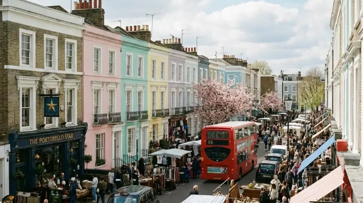
Portobello Road is one of the strongest surviving links between Notting Hill’s commercial past and its modern identity.
The road is approximately 1.5 kilometres long and runs north from Notting Hill Gate. The Royal Borough of Kensington and Chelsea identifies it as a major local and visitor destination.
The market began in 1865. Its original role was primarily local rather than the international tourist attraction associated with the street today. Over time, different forms of trading developed along the road.
The antiques trade became particularly important during the twentieth century. By the 1950s, Portobello Road had developed into a recognised antiques centre.
This transformation altered the commercial profile of the area. Antique shops, second-hand goods, books, clothing, food stalls and independent retailers created a distinctive retail environment.
The market developed different trading sections. Historical planning documentation identifies antiques and bric-a-brac in the southern section, new goods and food trading in the central section, and flea-market activity farther north during the main weekend trading periods.
The commercial importance of Portobello Road also helped connect different communities. Shops and markets served local residents while attracting customers from other parts of London and eventually international visitors.
The street became one of the clearest physical expressions of Notting Hill’s commercial diversity.
Its importance continues because the market retains functions that existed before Notting Hill became associated with high-value property and international tourism.
How did immigration transform Notting Hill’s social history?
Post-war migration transformed Notting Hill by establishing strong Caribbean communities, businesses, cultural institutions and social networks, especially in North Kensington, permanently changing the neighbourhood’s population and making multicultural identity central to its modern history.
The decades after the Second World War brought major demographic changes.
Caribbean migrants arrived in Britain in significant numbers during the post-war period. Many settled in London, including North Kensington, where affordable accommodation and existing community networks provided opportunities for new residents.
The development of the Caribbean community changed local commerce and culture. Shops, cafés, restaurants, churches, music venues and community organisations became important parts of everyday life.
This period also exposed serious racial inequality. Housing discrimination and social tensions affected Caribbean residents and other minority communities.
The 1958 Notting Hill disturbances became a major event in the district’s twentieth-century history. The violence reflected wider racial tensions, housing problems and hostility toward Caribbean migrants.
The historical significance of the period extends beyond the disturbances themselves. Community organisations and activists responded by creating spaces for cultural expression and solidarity.
The Royal Borough’s planning evidence describes the longstanding Afro-Caribbean community in the Portobello and Colville area as having made a major cultural contribution since the 1950s. It also identifies Spanish, Portuguese, Moroccan, Somali, West Indian and East Asian communities as part of the area’s later diversity.
This demographic transformation is essential to understanding why Notting Hill became culturally distinctive.
Its identity did not develop only from architecture, markets or property. Migration created new institutions, traditions, businesses and cultural practices that became permanent components of local history.
How did the Notting Hill Carnival change the neighbourhood’s cultural identity?
The Notting Hill Carnival developed from Caribbean community activism in the late 1950s and early 1960s, becoming an annual public celebration that established North Kensington as one of Britain’s most important centres of Caribbean cultural heritage.
The carnival has roots in the response to racism and discrimination experienced by Caribbean communities in London.
The Victoria and Albert Museum records that the origins of the carnival lie in the late 1950s, when Caribbean immigrants faced discrimination and racist abuse. Community activists organised cultural events as forms of unity and resistance.
Claudia Jones was a major figure in this early history. Jones was a Trinidad-born journalist and political activist who organised an indoor Caribbean carnival in London in 1959. The event helped establish a public platform for Caribbean culture.
The tradition later moved toward a street-based format in Notting Hill.
In 1966, an outdoor festival took place in the area. This event became an important foundation for the modern Notting Hill Carnival.
The carnival developed into a major annual event featuring music, costume, dance, food and community participation.
Its importance extends beyond entertainment. It records the history of Caribbean migration, racial politics, community organisation and cultural recognition in post-war Britain.
Notting Hill therefore became associated internationally with a form of cultural expression created by communities that had experienced marginalisation.
The carnival also reinforced the relationship between North Kensington’s streets and its social history. Roads became public cultural spaces during the annual event.
This transformed the external perception of the neighbourhood. Notting Hill became recognised not only for Victorian architecture and Portobello Road but also for Caribbean heritage and multicultural London.
How did Notting Hill change during the post-war decades?
After the Second World War, Notting Hill experienced major social, architectural and economic changes as migration, public housing, road construction, cultural activity and changing property markets reshaped different parts of the neighbourhood.
The post-war period produced significant contrasts across Notting Hill.
North Kensington retained substantial working-class communities and areas of social housing. Elsewhere, older Victorian properties faced deterioration, subdivision and changing patterns of occupation.
The Westway became another major physical influence. Constructed as part of London’s road infrastructure, the elevated dual carriageway altered the urban landscape of North Kensington and created spaces underneath the structure that later acquired community and commercial uses.
At Notting Hill Gate, post-war redevelopment created a very different architectural environment.
The Royal Borough records that much of the current retail centre received planning permission in 1957 and 1958 following road-widening schemes. The redevelopment also involved the reconstruction of the Underground station beneath the road.
This introduced larger buildings and a more vehicle-oriented urban environment.
The contrast between these modern structures and surviving Victorian streets became an important feature of the area’s visual character.
At the same time, Notting Hill developed a reputation for independent commerce, music, arts, antiques and alternative cultural activity.
The Royal Borough describes the area’s internationally recognised character as deriving from its combination of local shopping, bookshops, antiques and second-hand goods. It also records that this character reached a high point around the early 1970s before later property-price increases altered the area.
This cultural reputation became one of the foundations of later regeneration and gentrification.
When did Notting Hill become an expensive and highly desirable neighbourhood?
Notting Hill became increasingly expensive from the late twentieth century as historic housing, transport connections, cultural reputation and central London demand attracted wealthier residents, producing substantial property-price growth and demographic change from the 1990s onward.
The rise in property values was closely connected with Notting Hill’s existing assets.
Victorian terraces provided distinctive housing. Portobello Road supplied an established commercial destination. Westbourne Grove developed a strong independent retail identity. Underground connections provided access to central London.
These characteristics increased demand for residential property.
The Royal Borough records dramatic property-price increases over the two decades preceding its planning assessment and links those increases with demographic changes and alterations to the local retail economy.
The process is commonly described as gentrification. Gentrification is the socioeconomic transformation of an area as higher-income residents and investment enter a neighbourhood, often increasing property values and changing the commercial environment.
In Notting Hill, the process affected both residential and commercial space.
Some traditional independent businesses faced higher rents. The Royal Borough reported that increasing rents and rates affected antiques traders and smaller independent shops.
The transformation did not erase the older community. Instead, different social groups increasingly occupied the same geographical area.
This produced a complex socioeconomic landscape. Planning documents describe Portobello and its surrounding area as containing both high-income residents and lower-income households, alongside communities with Spanish, Portuguese, Moroccan, Somali, West Indian and East Asian backgrounds.
The modern neighbourhood therefore contains several historical layers simultaneously.
Which historic buildings and landscapes still survive in Notting Hill?
Notting Hill retains Victorian terraces, garden squares, market buildings, cinemas, churches, former industrial structures and protected conservation areas that preserve evidence of the neighbourhood’s nineteenth- and twentieth-century transformation.
The built environment provides direct evidence of Notting Hill’s historical development.
Ladbroke Square and surrounding streets retain the planned form associated with nineteenth-century estate development. Other streets preserve Victorian terraces and later Edwardian additions.
The Royal Borough’s Ladbroke Conservation Area appraisal identifies numerous historically significant structures, including the Electric Cinema on Portobello Road, North Kensington Library, the Notting Hill Fire Station, the former St Peter’s Church Hall and Holland Park Underground station.
The Electric Cinema is particularly significant to the cultural history of the area. The building dates from 1910–1911 and was designed by architect Gerald Seymour Valentin. It is listed at Grade II* level.
The Gate Theatre also survives as an important cultural building at Notting Hill Gate. The Royal Borough describes the Gate Cinema as built in 1911 and recognised as an iconic historic venue.
Notting Hill’s conservation system protects much of this architectural inheritance. The Royal Borough states that nearly three quarters of the borough is covered by 38 conservation areas, with the purpose of preserving or enhancing architectural and historic character.
The Ladbroke Conservation Area is one of these protected areas.
Conservation does not freeze a neighbourhood in time. Planning policy allows change while requiring development to consider the established character and appearance of protected areas.
This approach has helped retain the physical evidence of nineteenth-century Notting Hill while allowing modern residential, commercial and cultural uses.
How did Notting Hill’s historic identity influence tourism and popular culture?
Notting Hill’s combination of Victorian architecture, Portobello Road, Caribbean heritage, carnival traditions, independent commerce and cinema history turned the neighbourhood into a major London cultural destination with an identity recognised far beyond Britain.
Tourism developed from the interaction of several historical features rather than from one attraction.
Portobello Road became a major visitor destination through its market and antiques trade. The carnival created international recognition for North Kensington’s Caribbean cultural heritage. Victorian architecture provided a distinctive residential landscape.
Cinema also strengthened the neighbourhood’s public image.
The 1999 film Notting Hill, starring Hugh Grant and Julia Roberts, brought the neighbourhood’s name to a global audience. The film used locations across London, including areas associated with Notting Hill, and reinforced the connection between the district and popular culture.
However, the area’s historical identity predates the film by centuries.
The Royal Borough describes Portobello Road as one of London’s most visited attractions and identifies its market as an important cultural and commercial asset.
Notting Hill Gate also remains a significant transport and commercial centre. Its Underground station serves the Central, District and Circle lines, connecting the area with other parts of London.
For visitors, the result is a neighbourhood where architectural history, markets, migration history and contemporary commerce exist within a relatively compact geographical area.
To experience this historic neighbourhood in person today, consult our comprehensive [Discover Notting Hill’s Most Beautiful Streets, Cafés, and Local Attractions Easily] for itineraries and visiting parameters.
Tourism also creates preservation pressures. Increased visitor numbers generate economic activity but increase demand for commercial space and public infrastructure.
The historical character of Notting Hill therefore remains connected to contemporary planning decisions.
How has preservation shaped Notting Hill’s modern identity?
Preservation has protected significant terraces, garden squares, streetscapes and historic buildings while planning controls have managed later development, allowing Notting Hill to retain visible evidence of nineteenth-century expansion alongside twentieth- and twenty-first-century urban change.
The preservation of Notting Hill’s character results from a combination of listed-building protection, conservation-area designation and local planning policy.
Conservation areas recognise districts with special architectural or historic interest. The Royal Borough explains that its planning framework seeks to preserve or enhance their character and appearance.
The Ladbroke Conservation Area is particularly important because it preserves a substantial section of the nineteenth-century planned suburb.
Other conservation areas cover different historical layers. The borough identifies areas including Pembridge, Kensington Palace, Kensington, Norland and Oxford Gardens, each containing different combinations of architectural periods and development patterns.
Archaeological protection is also relevant. Historic England identifies archaeological priority areas associated with evidence of Roman activity and burials. The development of nineteenth-century streets exposed Roman remains, including sarcophagi and burials around Lansdowne Crescent and Ladbroke Grove.
This evidence demonstrates that Notting Hill’s heritage exists beneath the visible Victorian streets as well as within them.
Modern planning must therefore balance housing demand, commercial requirements, transport infrastructure, architectural conservation and archaeological significance.
The result is an urban district where historical continuity is visible but not absolute.
How did Grenfell Tower become part of Notting Hill’s modern history?
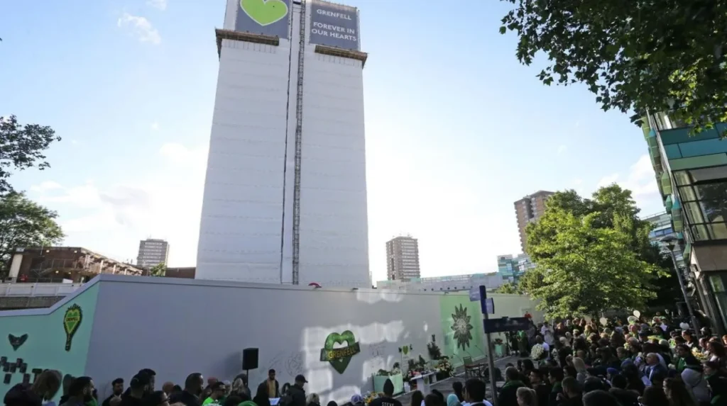
Grenfell Tower became a defining part of North Kensington’s modern history after the catastrophic fire of 14 June 2017, which killed 72 people and exposed major failures in building safety, regulation, housing management and institutional responsibility.
Grenfell Tower was a residential high-rise in North Kensington. The fire on 14 June 2017 became one of the most significant disasters in modern British housing history.
The tower stood within a community already shaped by migration, social housing, cultural activism and longstanding economic inequality.
The Grenfell Tower Inquiry investigated the causes of the fire and the institutional circumstances that preceded it. Its Phase 2 report was published in September 2024 and examined the wider chain of events, including decisions surrounding the building and its management.
The disaster cannot be separated from the broader history of North Kensington.
The area had experienced industrial development, working-class settlement, Caribbean migration, community organisation and later property-price pressures. Grenfell Tower existed within this complex urban environment.
The inquiry established a major historical record for understanding the disaster and its institutional context.
Grenfell also changed the contemporary meaning of North Kensington. Memorials, community organisations and public discussions about housing safety became part of the neighbourhood’s ongoing history.
For historians, the event represents another major layer in the long transformation of Notting Hill.
It also demonstrates that the history of a neighbourhood is not limited to architectural landmarks. Housing policy, public administration, social inequality and community memory are equally important historical forces.
Why is Notting Hill considered one of London’s most iconic neighbourhoods?
Notting Hill became iconic because its identity combines Roman-era routes, nineteenth-century planned architecture, market history, Caribbean migration, carnival culture, independent commerce, cinema heritage, conservation and modern social history within one London neighbourhood.
The transformation of Notting Hill occurred over several centuries but accelerated dramatically after 1820.
The first major phase involved the replacement of open land and extractive industries with planned residential estates. The Ladbroke Estate created the terraces and garden squares that still define large parts of the district.
The second phase involved transport and commercial expansion. Railways connected the area to the wider metropolis, while Portobello Road developed from a local market into an internationally recognised trading destination.
The third phase followed post-war migration. Caribbean communities established businesses, organisations and cultural traditions that changed the social history of North Kensington.
The Notting Hill Carnival became the most visible expression of this transformation. Its origins in community activism linked the neighbourhood directly to the history of migration, race relations and multicultural Britain.
The fourth phase involved cultural and economic change. From the late twentieth century, rising property values attracted wealthier residents and increased investment. The resulting gentrification altered demographics and retail patterns while leaving many older institutions intact.
The fifth phase is preservation and historical memory. Conservation areas protect much of the nineteenth-century built environment, while listed buildings preserve important cinemas, public buildings and architectural landmarks.
Notting Hill therefore represents multiple periods at once.
Its streets reveal Victorian urban planning. Its market records nineteenth- and twentieth-century commerce. Its carnival represents Caribbean London. Its property market demonstrates contemporary urban economics. Its conservation areas preserve architectural history. North Kensington’s community history records migration, inequality and political change.
The neighbourhood’s iconic status comes from this accumulated historical structure.
Notting Hill was not created as an iconic district. It became one through successive transformations that left physical, social and cultural evidence across its streets.
Its future historical importance will depend on how London manages the tension between conservation, housing needs, commercial change, cultural heritage and community identity.
The surviving terraces, garden squares, markets, cinemas and community traditions provide an unusually clear record of that process. Together, they explain why Notting Hill remains one of London’s most recognisable and historically significant neighbourhoods.
Historical timeline of Notting Hill
16th century onward: Gravel and brickearth extraction becomes an important feature of the wider Kensington landscape.
1836–1842: The short-lived Hippodrome racecourse operates before its closure opens the way for later estate development.
1837: The Great Western Railway is formed, supporting the expansion of settlements to the west and north of London.
1840s onward: Ladbroke Estate development establishes extensive Victorian terraces and garden-square housing.
1864: The turnpike gate at Notting Hill Gate is removed after operating on the historic western road.
1865: Portobello Road Market begins.
Late 19th century: North Kensington develops rapidly, with housing, industry and transport infrastructure replacing much of the remaining open land.
1910–1911: The Electric Cinema is constructed on Portobello Road.
1911: The Gate Cinema building opens at Notting Hill Gate.
1950s: Caribbean migration and community development become increasingly important to North Kensington.
1957–1958: Major redevelopment takes place around Notting Hill Gate as part of road-widening and transport changes.
1958: Racial violence in Notting Hill exposes severe tensions surrounding race, housing and migration.
1959: Claudia Jones organises an early Caribbean carnival event in London, contributing to the cultural movement that later develops into Notting Hill Carnival.
1966: An outdoor festival in Notting Hill becomes a foundation of the modern carnival tradition.
1970s: Notting Hill’s bohemian and independent commercial reputation becomes internationally recognised.
1990s onward: Rapid property-price growth contributes to demographic and commercial change.
1999: The film Notting Hill brings the neighbourhood’s name to a global popular-culture audience.
2015: The Ladbroke Conservation Area appraisal is formally adopted, reinforcing protection of the area’s architectural character.
2017: Grenfell Tower fire kills 72 people and becomes a defining event in North Kensington’s modern history.
2024: The Grenfell Tower Inquiry Phase 2 report is published, establishing an extensive official historical record of the causes and institutional circumstances surrounding the disaster.
Notting Hill’s history remains visible because its major transformations did not completely replace one another. Victorian terraces stand alongside post-war buildings. Portobello Market operates within a neighbourhood shaped by Caribbean migration. Conservation areas protect nineteenth-century layouts while modern development continues around them.
That layered history explains the area’s enduring significance. Notting Hill is both a historic London suburb and a record of the city’s wider transformation through industrialisation, migration, transport expansion, cultural change, property investment and heritage preservation.
For history enthusiasts, cultural tourists, educators and researchers tracing London’s communities, the neighbourhood provides a concentrated example of how London’s urban landscape changes while retaining evidence of earlier periods.
Frequently Asked Question
How did Notting Hill become a neighbourhood?
Notting Hill developed rapidly during the nineteenth century when open land, gravel pits and agricultural areas were replaced by residential estates. The Ladbroke Estate played a major role in creating the Victorian terraces and garden squares that still characterise the area.