London’s hidden alleys form one of the most remarkable surviving elements of the city’s historic landscape. While famous landmarks dominate guidebooks, hundreds of narrow lanes, courts, passages, and yards continue to preserve the physical layout of medieval, Tudor, Georgian, and Victorian London. These spaces survived devastating fires, rapid industrialisation, wartime bombing, and extensive redevelopment because they fulfilled practical economic, legal, and social functions that larger streets could not replace.
- Why do London’s hidden alleys still exist today?
- How did medieval London create its network of hidden alleys?
- How did property ownership help preserve London’s historic street pattern?
- Why did the Great Fire of 1666 not erase London’s hidden alleys?
- How did commerce keep narrow alleys economically valuable?
- How did Victorian redevelopment reshape rather than remove hidden alleys?
- How did war and twentieth-century redevelopment affect London’s hidden alleys?
- Which historic alleys best illustrate London’s survival across centuries?
- What do London’s hidden alley names reveal about the city’s past?
- How do archaeology and historical records explain London’s hidden alleys?
- How are London’s hidden alleys protected today?
- Why do London’s hidden alleys remain historically important?
Today, London’s historic alleys remain valuable records of urban development. Their names preserve forgotten occupations, markets, religious institutions, and influential families. Their layouts reveal how commerce, housing, governance, and transport evolved across nearly two thousand years. Many are protected through conservation policies, heritage legislation, and careful restoration, ensuring they continue to contribute to London’s cultural identity.
Why do London’s hidden alleys still exist today?
London’s hidden alleys survived because successive generations adapted them rather than replacing them. Medieval property ownership, commercial demand, conservation laws, architectural resilience, and heritage protection preserved many historic passages despite repeated disasters and centuries of urban redevelopment across the capital.
The continued existence of London’s hidden alleys reflects the city’s unusual pattern of gradual evolution instead of complete reconstruction. Unlike many European capitals that underwent comprehensive urban redesign, London expanded through incremental redevelopment. Existing streets often remained because surrounding land ownership made wholesale replacement impractical.
Many alleys originated during the medieval period between the eleventh and fifteenth centuries. Property owners divided valuable land into narrow plots, creating small access routes that connected homes, workshops, churches, markets, and riverside wharves. These routes became legally recognised public rights of way, making their removal increasingly difficult.
Following the Norman Conquest of 1066, London’s population expanded steadily. Commercial districts around Cheapside, Cornhill, Fleet Street, and the Thames waterfront required increasingly efficient pedestrian movement. Narrow passages connected merchants, craftsmen, warehouses, and parish churches while maximising valuable building space.
Over centuries, rebuilding generally occurred within existing property boundaries rather than through complete street redesign. Consequently, medieval street patterns frequently survived beneath newer Georgian and Victorian buildings.
The continuity of legal property rights also contributed significantly. Individual landowners rebuilt structures after fires or redevelopment while preserving existing boundaries. As a result, alley alignments established hundreds of years earlier remained embedded within the city’s legal framework.
How did medieval London create its network of hidden alleys?
Medieval London’s economy depended on dense networks of narrow lanes that connected markets, guild halls, churches, residences, workshops, and river transport. Property subdivision and defensive urban planning produced street patterns that remained largely unchanged for centuries after their creation.
Roman Londinium established London’s earliest street grid after AD 43. While much of the Roman city disappeared following imperial withdrawal, certain routes influenced later medieval development.
By the twelfth century, London’s growing commercial importance encouraged intensive urban construction. Building plots remained narrow because land close to markets and river crossings commanded exceptionally high value.
Guilds representing occupations including goldsmiths, fishmongers, mercers, and drapers established headquarters within distinct neighbourhoods. Workers required efficient pedestrian routes linking workshops with markets, storage buildings, and residential areas.
Religious institutions also shaped London’s street network. Monasteries, churches, hospitals, and charitable foundations acquired extensive urban property. Their internal courts and access passages later became public alleys after the Dissolution of the Monasteries during the sixteenth century.
Markets generated further complexity. Trading activity concentrated around specific commodities including fish, meat, cloth, spices, and imported luxury goods. Narrow connecting passages improved movement between specialised commercial districts.
The resulting urban fabric consisted of interconnected streets, lanes, courts, yards, and passages that maximised economic efficiency while accommodating growing population density.
How did property ownership help preserve London’s historic street pattern?
Historic property boundaries prevented extensive street redesign because land ownership remained fragmented across thousands of individual plots. Rebuilding usually respected established legal boundaries, allowing medieval alley alignments to survive continuous architectural change from the Middle Ages onward.
English property law strongly influenced London’s physical development.
Rather than government-controlled urban planning, much of medieval and early modern London consisted of privately owned parcels inherited through families, sold between merchants, or managed by religious institutions.
Each redevelopment project affected only individual plots. Owners rebuilt houses, warehouses, shops, and offices while maintaining existing legal boundaries. Consequently, passageways separating neighbouring properties remained intact.
This gradual process differed significantly from cities rebuilt according to uniform master plans.
Numerous estates controlled by aristocratic families—including the Bedford Estate, Grosvenor Estate, and Crown Estate—also retained historic internal routes while developing surrounding neighbourhoods.
Legal rights of access further complicated redevelopment. Businesses, residents, churches, and commercial premises depended upon established routes for deliveries and pedestrian movement. Removing an alley often required complex negotiations involving multiple property owners.
These legal constraints preserved many medieval alignments beneath increasingly modern architecture.
Why did the Great Fire of 1666 not erase London’s hidden alleys?
The Great Fire destroyed buildings rather than property boundaries. Reconstruction largely followed existing street layouts because land ownership disputes, rebuilding costs, and commercial urgency prevented planners from implementing entirely new road systems throughout the devastated city.
The Great Fire began on 2 September 1666 and destroyed approximately 13,200 houses, 87 parish churches, numerous public buildings, and much of the medieval City of London.
Architects including Sir Christopher Wren proposed ambitious redesigns featuring broad boulevards and geometric street plans inspired by continental European cities.
However, these proposals proved impractical.
Thousands of individual landowners expected reconstruction on their original plots. Resolving ownership claims delayed rebuilding even under existing boundaries. Implementing entirely new street plans would have required extensive compulsory land acquisition and compensation.
The Rebuilding Act of 1667 introduced improved building standards, including greater use of brick and stone instead of timber, wider principal streets, and enhanced fire safety.
Nevertheless, most smaller lanes remained where they had stood before the fire.
As rebuilding accelerated during the late seventeenth century, merchants prioritised restoring commercial activity rather than pursuing comprehensive urban redesign. London’s medieval street network therefore remained largely intact despite widespread architectural renewal.
How did commerce keep narrow alleys economically valuable?
London’s hidden alleys remained commercially useful because they provided direct access to workshops, warehouses, counting houses, markets, printing businesses, legal chambers, and river transport, supporting economic activity across successive historical periods despite changing industries and technologies.
Commercial necessity repeatedly justified preserving narrow routes.
During the medieval period, merchants transported goods by handcart between riverside wharves and inland markets.
The Tudor economy expanded international trade through the River Thames, increasing demand for warehouse access.
By the seventeenth century, London’s financial institutions clustered around Cornhill and Lombard Street. Nearby courts and passages accommodated banking offices, insurers, coffee houses, and merchant companies.
Fleet Street became Britain’s publishing centre during the eighteenth and nineteenth centuries. Numerous printing workshops occupied narrow courts behind principal streets where rents remained comparatively affordable.
Legal professionals concentrated around the Inns of Court, where interconnected passages linked chambers, libraries, gardens, and courts.
Industrialisation introduced additional commercial uses. Warehouses, workshops, artisans, and wholesalers occupied spaces unsuitable for larger buildings but ideal for compact businesses requiring central locations.
Economic adaptation prevented many alleys from becoming obsolete.
How did Victorian redevelopment reshape rather than remove hidden alleys?
Victorian engineers modernised sanitation, transport, and infrastructure while preserving many historic routes. New railway stations, sewer systems, and commercial buildings surrounded older passages instead of eliminating every surviving medieval and early modern street.
The nineteenth century transformed London into the world’s largest city.
Population growth exceeded six million by 1900, creating enormous pressure for improved infrastructure.
Major engineering projects included Joseph Bazalgette’s sewer system, new bridges, underground railways, and railway termini.
Large redevelopment schemes removed some historic districts.
However, complete street replacement remained rare because compensation costs proved substantial and commercial continuity remained essential.
Victorian architects frequently constructed larger office blocks around surviving internal courts.
Covered passages also became fashionable retail environments, combining historical layouts with modern architecture.
Municipal improvements widened principal roads while leaving secondary pedestrian routes largely intact.
Consequently, Victorian London combined modern engineering with medieval spatial organisation.
Many hidden alleys visible today therefore contain Victorian buildings occupying much older street alignments.
How did war and twentieth-century redevelopment affect London’s hidden alleys?
Twentieth-century bombing destroyed thousands of buildings, yet reconstruction again respected numerous historic street alignments. Conservation policies introduced after the Second World War increasingly recognised historic alleys as essential components of London’s architectural and cultural heritage.
The Blitz between 1940 and 1941 caused catastrophic destruction across London.
Historic districts within the City suffered particularly heavy bombing because financial institutions, docks, and transport infrastructure represented strategic targets.
Many medieval buildings disappeared.
Yet planners again faced familiar challenges.
Existing street networks remained legally established and economically practical.
Post-war reconstruction prioritised office development while maintaining numerous pedestrian routes linking commercial districts.
Growing public appreciation of architectural heritage during the twentieth century fundamentally changed planning priorities.
The Civic Amenities Act 1967 introduced conservation areas protecting historic urban character rather than isolated monuments alone.
Subsequent heritage legislation strengthened safeguards for historically significant streetscapes.
Conservation officers increasingly recognised that London’s identity depended upon preserving complete urban environments, including modest alleys alongside major landmarks.
Which historic alleys best illustrate London’s survival across centuries?
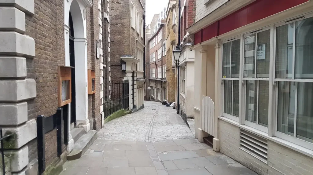
Several surviving alleys demonstrate different periods of London’s history through preserved layouts, architecture, commercial functions, and archaeological evidence. Together they illustrate medieval commerce, Tudor expansion, Georgian development, Victorian adaptation, and modern conservation across the capital.
Several locations demonstrate how London’s urban history remains physically visible.
Leadenhall’s narrow passages preserve connections with one of the city’s oldest market districts.
St Dunstan’s Court reflects medieval parish organisation surrounding historic churches.
Cloth Fair follows property boundaries associated with the medieval cloth trade.
Mitre Court illustrates legal and commercial development around Fleet Street.
Goodwin’s Court retains eighteenth-century architectural character with remarkably intact façades.
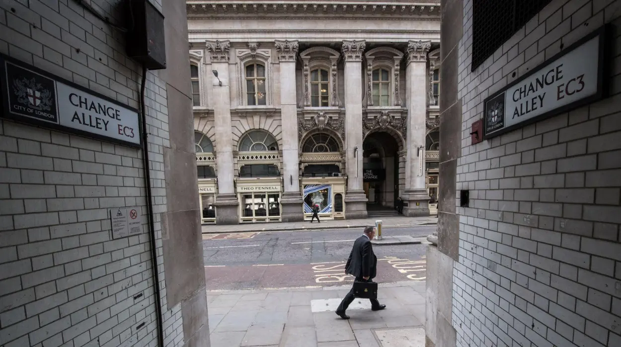
Exchange Alley reflects London’s emergence as an international financial centre following the establishment of early stock trading and coffee-house commerce.
Each location preserves distinct historical evidence through street layout, building alignment, names, and surviving architecture.
To experience these historic locations in person today, consult our comprehensive [Best Hidden Gems in London Worth Visiting] for itineraries and visiting parameters.
What do London’s hidden alley names reveal about the city’s past?
Historic alley names preserve evidence of medieval occupations, influential families, religious institutions, commercial activities, and geographic features. These names function as linguistic archaeological records that reveal how London developed socially, economically, and administratively across many centuries.
Street names frequently survive longer than buildings.
Consequently, London’s alley names preserve valuable historical information.
Names including Bread Street, Milk Street, Honey Lane, and Poultry identify specialised medieval markets.
Others commemorate occupations such as Ironmonger Lane, Wood Street, and Bow Lane.
Religious influence appears through names referencing churches, monasteries, saints, and ecclesiastical property.
Family names identify influential landowners whose estates shaped neighbourhood development.
Some names preserve physical landscape features that disappeared centuries ago, including streams, gardens, orchards, and defensive walls.
Linguists and historians use these surviving names alongside documentary records to reconstruct London’s historical geography.
Street nomenclature therefore represents an important source for urban historical research.
How do archaeology and historical records explain London’s hidden alleys?
Excavations, property surveys, tax records, parish registers, historic maps, and municipal archives collectively document London’s evolving street network. These complementary sources confirm that many surviving alleys retain alignments established several centuries before modern redevelopment occurred.
Modern archaeological investigations have significantly expanded understanding of London’s historic development.
Excavations undertaken before commercial construction frequently uncover Roman roads, medieval foundations, drainage systems, wells, workshops, and domestic structures beneath modern streets.
Historic mapping provides additional evidence.
John Rocque’s eighteenth-century survey, Richard Horwood’s late eighteenth-century mapping, and Victorian Ordnance Survey plans document remarkable continuity in London’s street network.
Property deeds reveal changing ownership while confirming consistent legal boundaries.
Parish registers record residents, occupations, baptisms, marriages, and burials associated with individual courts and alleys.
Tax records identify commercial activity concentrated within particular districts.
Together these documentary and archaeological sources create a comprehensive record explaining why many hidden alleys survived successive rebuilding campaigns.
How are London’s hidden alleys protected today?
Heritage legislation, conservation areas, listed buildings, planning controls, archaeological oversight, and public engagement protect London’s hidden alleys. Preservation focuses on maintaining historic character while allowing sensitive adaptation that supports modern commercial and public use.
Historic preservation now forms an integral component of London’s planning system.
Many surviving alleys lie within designated conservation areas where redevelopment undergoes careful assessment.
Individual buildings receive statutory listing according to architectural and historic significance.
Planning authorities evaluate proposals affecting historic streetscapes, materials, building heights, and visual character.
Archaeological assessments frequently accompany major construction projects.
Developers document buried remains before excavation proceeds.
Public organisations promote awareness through guided walks, educational programmes, heritage interpretation, and digital archives.
Conservation therefore extends beyond preserving buildings.
It also protects historical relationships between streets, plots, open spaces, commercial functions, and architectural character.
This integrated approach ensures future generations continue to understand London’s historical evolution through its surviving urban landscape.
Why do London’s hidden alleys remain historically important?
London’s hidden alleys preserve continuous evidence of nearly two thousand years of urban history. Their layouts, names, buildings, and archaeological remains reveal how commerce, governance, architecture, transport, and everyday life evolved through successive historical periods while maintaining remarkable spatial continuity.
Hidden alleys represent living historical documents rather than isolated tourist attractions.
Their physical form demonstrates how cities evolve gradually through adaptation instead of constant replacement.
Every surviving passage reflects decisions made by merchants, craftsmen, religious institutions, architects, surveyors, legislators, conservationists, and local communities across many centuries.
Their preservation supports historical scholarship, genealogy, archaeology, architecture, urban planning, and cultural tourism.
Researchers continue discovering new evidence through archival study, archaeological excavation, and digital mapping technologies.
For visitors, these spaces provide direct access to London’s layered past beyond its internationally recognised monuments.
For educators, they offer tangible examples of medieval urbanism, property law, commercial development, and heritage conservation.
For preservationists, they demonstrate that successful cities protect ordinary historic environments alongside famous landmarks.
London’s hidden alleys therefore remain indispensable components of Britain’s architectural heritage and one of the clearest surviving records of how a global capital developed from a Roman settlement into a modern metropolis while retaining remarkable traces of every major period in its history.
Did the Great Fire of 1666 destroy London’s hidden alleys?
The Great Fire destroyed thousands of buildings, but most alley layouts survived because rebuilding respected existing property boundaries and legal ownership rather than creating an entirely new street plan.