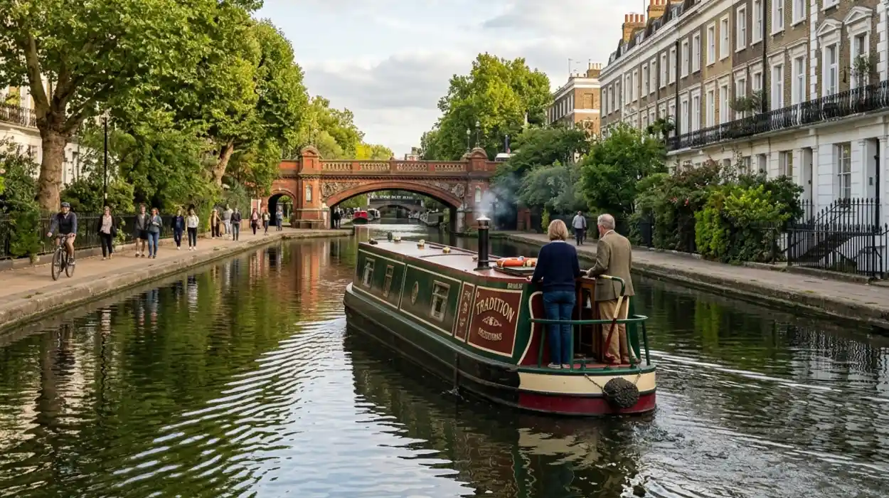
Little Venice is a picturesque residential district in West London known for its scenic canals, historical waterways, and distinct Regency architecture. Situated at the junction of the Grand Union Canal and the Regent’s Canal, this tranquil neighborhood provides a vital cultural and transport link within the British capital. Exploring this area by canal boat offers a direct connection to Camden Town, a vibrant cultural hub in North London. This comprehensive guide by Extra London News explores the deep historical origins of Little Venice, details the exact mechanics of traveling to Camden via the historic waterways, and analyzes the enduring cultural and economic impact of London’s canal network.
- What is the History of Little Venice?
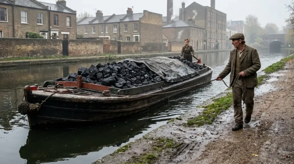
- The Industrial Origin of the Waterways
- Etymology and Cultural Evolution
- Preservation and Modern Status
- Why did London Build the Regent’s Canal?
- How do you Take a Canal Boat from Little Venice to Camden?
- What can you See Along the Regent’s Canal Route?
- Architecture of Regent’s Park
- The Zoological Society of London (ZSL)
- Floating Culture and Mooring Sites
- What is the History of Camden Lock?
- What is the Modern Economic and Environmental Value of London’s Canals?
What is the History of Little Venice?
Little Venice developed in the early nineteenth century as a critical junction for the Grand Union and Regent’s canals. Originally an industrial transit hub for industrial merchandise, the area evolved into a scenic, affluent residential neighborhood renowned for its unique Regency architecture.
The Industrial Origin of the Waterways
The development of Little Venice began with the construction of the Grand Junction Canal, authorized by an Act of Parliament in 1793. The canal reached Paddington in 1801, establishing a vital trade link between London and the industrial Midlands of England. Engineers designed the Paddington Basin to serve as a major transshipment point where goods transferred from horse-drawn canal barges to regional carts.
In 1812, the Regent’s Canal Company began constructing an extension from Paddington to the River Thames at Limehouse. This project, overseen by architect John Nash and engineer James Morgan, faced significant financial and structural delays before its completion in August 1820. The intersection of these two waterways formed a large triangular basin, known today as the Browning Pool, which serves as the geographic heart of Little Venice.
Etymology and Cultural Evolution
The origin of the name Little Venice is officially attributed to the prominent English poet Robert Browning, who resided at Warwick Crescent alongside the canal basin from 1862 to 1887. Browning famously compared the local waterways to the canals of Venice, Italy. However, historical records indicate that the satirical writer Lord Byron also applied the term to the area earlier in the nineteenth century, using it to describe the scenic properties near the water toll house.
During the Victorian era, the neighborhood surrounding the basin transitioned from a busy commercial zone into a highly desirable residential district. Architects built rows of white stucco-fronted Regency detached houses and terraces along the waterways, attracting artists, writers, and wealthy professionals. The area retained its distinct architectural character through the twentieth century, resisting major redevelopment efforts during the post-war era.
Preservation and Modern Status
The commercial decline of British canals after World War II threatened the structural integrity of the Paddington and Regent’s canals. The introduction of railway networks and motorized road transport reduced the commercial viability of horse-drawn freight barges. By 1960, commercial cargo traffic through Little Venice had effectively ceased.
In response to potential infilling projects, local conservation groups and the Inland Waterways Association successfully campaigned to preserve the canal network for recreational use. The local authority, the City of Westminster, designated the Maida Vale and Little Venice areas as conservation zones in 1968 to protect the Regency architecture and riparian ecosystems. Today, the Canal & River Trust manages the infrastructure, maintaining the basin as a permanent mooring site for residential narrowboats and commercial tour vessels.
Explore More Things To Do
Best Kept Secrets Beyond Portobello Road — Notting Hill
Exploring Kew Gardens: Seasonal Guide and Highlights — Kew, Richmond
Why did London Build the Regent’s Canal?
London constructed the Regent’s Canal to create an efficient bypass route linking the Grand Junction Canal at Paddington directly to the River Thames at Limehouse. This infrastructure facilitated the rapid, high-volume transport of industrial commodities across the growing metropolis.
Addressing the Industrial Bottleneck
During the onset of the Industrial Revolution, London experienced unprecedented population growth and commercial expansion. The existing road networks were unpaved, prone to severe muddy conditions, and incapable of handling the heavy freight required to fuel the city’s industries. The Grand Junction Canal successfully brought raw goods from the north of England to Paddington, but transporting those goods across London to the eastern docks remained a slow and expensive process.
The Regent’s Canal solved this logistical bottleneck by providing a continuous, water-based transport highway through the northern periphery of the capital. It allowed industrial operators to bypass the congested central streets of London entirely. Barges moved massive quantities of materials directly from the midland manufacturing centers to international shipping vessels anchored in the Thames Tideway.
Key Commodities Transported
The canal network operated as the primary distribution artery for several essential commodities that sustained London’s infrastructure. These goods included:
- Coal: Extracted from the mines of Warwickshire and Nottinghamshire to power London’s gasworks, factories, and residential fireplaces.
- Timber: Imported from international ports and distributed to construction sites across the expanding northern suburbs of Marylebone, St Pancras, and Islington.
- Agricultural Produce: Grain, hay, and livestock feed brought from rural counties to supply the central markets of Smithfield and Covent Garden.
- Building Materials: Granite, bricks, and slate transported from Wales and the Midlands to construct Victorian residential terraces.
Financial and Engineering Challenges
The construction of the Regent’s Canal required significant capital and advanced civil engineering to navigate the undulating topography of North London. The project cost over £1.2 million, which significantly exceeded the initial estimates provided by the project promoters. Investors faced financial panics, and construction halted completely in 1815 due to a lack of available funds until the Exchequer Bill Loan Commission provided a critical government loan.
From an engineering perspective, James Morgan had to design specialized structures to overcome elevation changes and urban obstacles. The route required the excavation of two major subterranean passages: the 251-meter Maida Hill Tunnel and the 886-meter Islington Tunnel. Because these tunnels lacked towpaths, barge crews had to move the vessels through the dark passages using a technique called “legging,” where men lay on their backs on planks across the boat and pushed against the brick walls with their feet.
How do you Take a Canal Boat from Little Venice to Camden?
Traveling from Little Venice to Camden by canal boat involves boarding a scheduled water bus service at the Browning Pool basin. The vessel navigates eastward along the historic Regent’s Canal, passing through the Maida Hill Tunnel and Regent’s Park.
Selecting a Boat Service Operator
Two primary commercial operators provide scheduled, legally compliant passenger water bus services between Little Venice and Camden Lock. These established companies utilize traditional, modified British narrowboats that conform to the strict safety regulations enforced by the Maritime and Coastguard Agency.
The London Waterbus Company operates historic vessels from its dedicated boarding point at the Browning Pool, situated close to the Warwick Avenue underground station. This service runs daily departures on an hourly or half-hourly basis depending on seasonal demand. The second operator, Jason’s Canal Boat Trips, runs a traditional vessel that has operated on this specific route since 1951, offering a narrated journey detailing the architectural and social history of the canal.
Route Geography and Key Landmarks
The boat journey covers a distance of approximately 2.5 miles (4 kilometers) and requires roughly 45 to 50 minutes to complete. After departing the Little Venice basin, the boat immediately enters the Maida Hill Tunnel, navigating through the dark brick vault beneath the streets of Edgware Road. Upon exiting the tunnel, the canal flows through the affluent district of St John’s Wood.
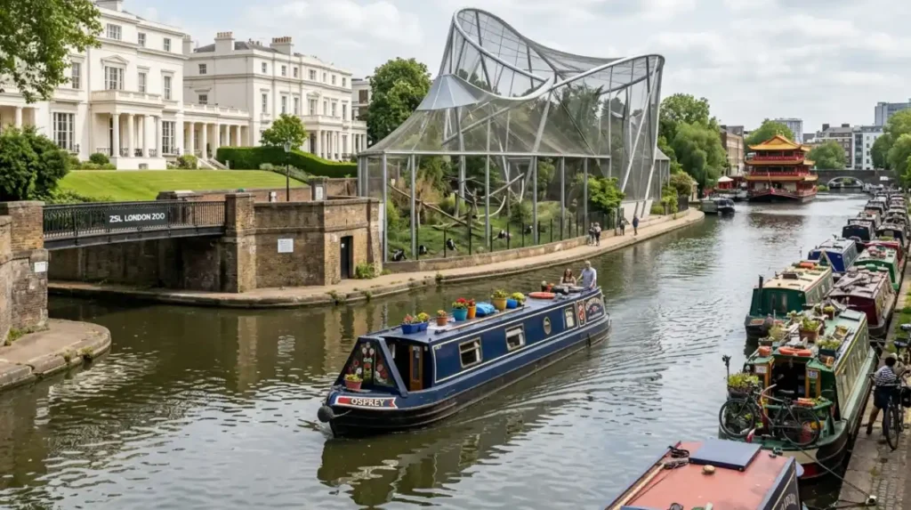
The waterway then cuts directly through the northern section of Regent’s Park. Passengers can observe the grand John Nash villas that border the water, followed by the open-air enclosures of the ZSL London Zoo. The boat passes directly beneath the historic Cumberland Turn and alongside the iconic Snowdon Aviary before entering the urban landscape of Camden Town, terminating finally at the Camden Lock market basin.
Ticketing and Boarding Logistics
Passengers can purchase tickets online in advance through the official operator websites or directly from the boat captains at the boarding points, subject to seat availability. The operators structure their fares into single (one-way) journeys and return (round-trip) tickets, with discounted rates available for children, senior citizens, and pre-booked tour groups.
The boats operate on a first-come, first-served basis for walk-up passengers, and boarding begins approximately 15 minutes before the scheduled departure time. The vessels feature enclosed cabins with large viewing windows to ensure operation during inclement British weather, while some boats also offer small open-air viewing decks at the stern. It is important to note that standard London transport cards, such as the Oyster card or contactless bank cards, are not accepted on these private heritage boat services.
Explore More Things To Do
London Budget Eats: Food Halls & Cheap Spots in Camden
London Kids Parks Museums Top Attractions Hyde Park Area
What can you See Along the Regent’s Canal Route?
The Regent’s Canal route features a diverse array of historic landmarks, architectural styles, and ecological habitats. Passengers can observe nineteenth-century mansions, engineering structures, the London Zoo enclosures, and unique floating residential communities throughout the journey.
Architecture of Regent’s Park
As the canal enters the northern perimeter of Regent’s Park, it provides a unique view of the grand palatial villas designed by John Nash in the 1820s. These Grade I listed classical buildings feature white stucco facades, Corinthian columns, and expansive private lawns that slope down directly to the water’s edge. The most prominent of these properties is Hanover Lodge, a historic mansion that exemplifies the elite residential architecture of the Regency era.
The canal also showcases the changing industrial aesthetic of London. Contrast arises between the classical villas and the functional brick retaining walls, cast-iron footbridges, and old stop-gates designed to control water flow in the event of a breach. Blow-Up Bridge, located near the outer circle of the park, is a notable historical structure rebuilt after a gunpowder barge exploded beneath it in 1874, destroying the original bridge and damaging nearby housing.
The Zoological Society of London (ZSL)
The canal cuts directly through the grounds of the ZSL London Zoo, which opened its doors to researchers in 1828 and the general public in 1847. The boat route offers passengers a free, close-up view of several animal enclosures situated on the canal banks.
The most architecturally significant structure visible from the water is the Snowdon Aviary. Designed by Lord Snowdon, Cedric Price, and Frank Newby in 1964, this pioneering aluminum and tension-mesh structure stands as a Grade II* listed monument. It represents a major milestone in post-war British architectural engineering and has since been repurposed as a naturalistic habitat for Eastern black-and-white colobus monkeys.
Floating Culture and Mooring Sites
The journey reveals the distinct lifestyle of London’s modern liveaboard boating community. Along the stretches of Maida Vale and Lisson Grove, the canal sides feature permanent residential moorings occupied by traditional British narrowboats. These vessels display colorful hand-painted decorations, traditional roses-and-castles artwork, and compact roof gardens.
At the Cumberland Basin, the canal widens near a junction that once led to a market slipway in Regent’s Park. This area features the Feng Shang Princess, a large, authentic three-tiered traditional Chinese restaurant boat permanently moored on the water. This structure highlights how the post-industrial canal system has adapted to host diverse commercial and culinary ventures within the urban fabric of London.
What is the History of Camden Lock?
Camden Lock developed in 1816 as a crucial industrial transshipment point featuring the first dual-lock system on the Regent’s Canal. In 1974, entrepreneurs converted the abandoned industrial wharves into a world-famous craft and cultural market network.
Engineering the Lock System
Camden Lock, officially registered as Hampstead Road Locks (Locks 1, 2, and 3), represents a major engineering feat executed by the Regent’s Canal Company. Engineers constructed the lock complex between 1816 and 1820 to manage a significant 2.5-meter drop in the landscape as the waterway travelled eastward toward Islington. It is the only dual-lock station on the entire length of the Regent’s Canal, featuring side-by-side chambers designed to accelerate boat traffic and conserve water volumes during operation.
The locks required a steady supply of water to function efficiently. To prevent water depletion during periods of drought or heavy commercial traffic, engineers installed a steam-powered pumping station at the lock site to pump water back up to the higher Paddington reach. The lock gates, originally constructed from solid English oak timber, now feature durable composite steel frames with traditional wooden balance beams for manual operation by passing boat crews.
The Commercial Warehousing Era
During the nineteenth and early twentieth centuries, Camden Lock operated as a sprawling industrial complex dedicated to the storage and distribution of consumer commodities. The area featured specialized commercial infrastructure, including:
- The Interchange Basin: A large water dock built by the London and North Western Railway to allow goods to transfer directly between canal boats and steam locomotives.
- The Horse Hospital: A multi-story brick complex built to provide veterinary care, stabling, and forage for the hundreds of heavy draft horses utilized to tow barges along the canal paths.
- The Gilbey’s Gin Complex: A massive complex of brick bonded warehouses and distilleries established by W&A Gilbey, which dominated the local economy from the 1860s until the mid-twentieth century.
Transformation into a Cultural Market
The decline of industrial canal shipping left the Camden Lock warehouses derelict by 1970. In 1971, a commercial real estate company called North Gower Street Associates purchased the wharf properties with the intention of preserving the industrial heritage structures rather than demolishing them for modern office high-rises. The company granted temporary short-term leases to local independent craftsmen, artists, and antique dealers.
On March 30, 1974, the Camden Lock Market officially opened to the public as a small weekend arts and crafts market featuring 16 individual stalls. The market grew exponentially over the following decades, evolving from a bohemian subcultural gathering space into a globally recognized tourist attraction. The market complex now attracts over 10 million visitors annually, supporting hundreds of permanent independent retailers, global street food vendors, and creative design studios within the historic brick fabric of the former industrial wharves.
What is the Modern Economic and Environmental Value of London’s Canals?
London’s canals generate significant modern economic value through international tourism, leisure business, and urban regeneration projects. Environmentally, these waterways function as critical green infrastructure corridors that preserve urban biodiversity and support sustainable transport.
Tourism and Local Economy
The transformation of the Regent’s Canal from an industrial freight line into a premier leisure destination has created a robust economic engine for London. Commercial boat cruise operators, waterside cafés, pubs, and independent retail markets generate substantial revenue and support thousands of hospitality jobs within the boroughs of Westminster and Camden.
Property values immediately adjacent to the canal network have experienced significant appreciation over the last thirty years. Modern real estate developers actively market residential apartments and commercial office complexes based on their proximity to the water, a trend seen in major urban regeneration initiatives like Paddington Central and King’s Cross Central. This economic revitalization demonstrates how legacy industrial infrastructure can be repurposed to attract corporate investment and high-density residential development.
Biodiversity and Urban Ecology
Beyond their economic utility, the canals of London operate as vital ecological corridors that slice through dense urban environments. The Canal & River Trust, working in partnership with local environmental charities, manages the waterways to maximize their habitat value for native British wildlife. The water and reed beds provide essential nesting sites and foraging grounds for numerous bird species, including mallards, moorhens, coots, grey herons, and common kingfishers.
The canal water column supports diverse fish populations, including European eels, perch, roach, bream, and pike. To enhance urban biodiversity, conservation teams install floating reed islands along the canal walls in areas like Little Venice and Camden. These artificial structures filter urban runoff water, provide shelter for juvenile fish, and encourage the growth of aquatic plants that would otherwise struggle to establish roots against the vertical concrete and brick retaining walls.
Sustainable Recreation and Alternative Transport
In the twenty-first century, the historic towpaths that border the Grand Union and Regent’s canals have taken on a vital new role as active travel corridors. The Canal & River Trust maintains these pathways to provide traffic-free, grade-separated routes for pedestrians and commuter cyclists navigating across North London. This infrastructure helps reduce traffic congestion on city streets and lowers carbon emissions by encouraging walking and cycling.
The waterways also offer unique space for recreational paddleboarding, canoeing, and kayaking, allowing urban residents to engage with nature without leaving the city. By balancing the preservation of nineteenth-century engineering heritage with modern ecological stewardship, London’s canal network remains a resilient, highly valued asset for the public. As urban centers continue to expand globally, the enduring success of Little Venice and the Regent’s Canal provides a proven blueprint for integrating industrial history, sustainable tourism, and green urban planning.
What Is the History of Little Venice?
Little Venice developed in the early 19th century as a key junction in London’s canal system. The Grand Junction Canal (now part of the Grand Union Canal) reached Paddington in 1801, and the Regent’s Canal opened in 1820, linking west London to the River Thames at Limehouse.