London’s Strand is one of the capital’s most historically layered streets because it connected two separate centres of power for centuries: the commercial City of London to the east and royal Westminster to the west. Its evolution records the making of metropolitan London itself. From an Anglo-Saxon riverside route to a medieval processional road, from a corridor of aristocratic palaces to a district of law, education, theatre, publishing, and transport, the Strand preserves the political, architectural, and social history of the city in a single east–west line.
- Why was the Strand so important in the history of London?
- What did the Strand look like before it became a grand London street?
- How did the Strand become a corridor of aristocratic palaces and mansions?
- Why did the aristocratic Strand decline as a residential district?
- How did religion, law, and monarchy shape the Strand’s identity?
- What changed on the Strand in the eighteenth and nineteenth centuries?
- How did twentieth-century rebuilding and traffic planning reshape the Strand?
- Which historic buildings and sites still show the Strand’s past today?
- Why does the Strand still matter in London’s history today?
The street runs from Trafalgar Square east to Temple Bar, where it meets Fleet Street. The name derives from the Old English strond, meaning shore or riverbank, a reminder that the road originally ran beside the north bank of the River Thames before embankment works altered the shoreline. The Strand was not merely a street. It was a strategic corridor between Westminster and the City, a preferred address for nobles and bishops, and later a centre of urban commerce, print culture, theatres, hotels, churches, and civic institutions. In historical terms, it offers a compressed map of London’s transition from medieval twin settlements to modern imperial capital.
For modern readers, the Strand matters because many of its historic functions remain visible. Somerset House still dominates the river side. St Clement Danes and St Mary le Strand still define the street’s eastern section. King’s College London occupies a major stretch of the route. Temple Bar still marks the historic threshold between Westminster and the City, even though Wren’s gateway itself was relocated and reconstructed elsewhere. The Strand is therefore not just old; it is a working historical document in built form.
Why was the Strand so important in the history of London?
The Strand became historically important because it linked medieval London’s two power centres, carried royal and legal traffic, attracted aristocratic residences, and later concentrated churches, theatres, courts, hotels, shops, and colleges. Its importance came from geography: it was the road between Westminster and the City along the Thames.
The most important fact about the Strand is positional. In the Middle Ages, the City of London and Westminster were not simply neighbourhoods of one metropolis. They were distinct centres with different functions. The City was the commercial and financial core, governed by its own civic institutions. Westminster was the political and royal centre, home to the Palace of Westminster, the monarchy, major ecclesiastical foundations, and the machinery of government. The Strand ran between them.
That made the route a corridor of movement for merchants, officials, courtiers, churchmen, lawyers, diplomats, and monarchs. It also made the area around it valuable. Anyone who needed access to both Westminster and the City had a practical reason to establish a residence or institution there. That is the basic mechanism behind the Strand’s long importance. Geography created traffic; traffic created prestige; prestige attracted investment, buildings, and institutions.
The Strand also developed beside the Thames, which mattered before the construction of the Victoria Embankment in the nineteenth century. River transport remained one of London’s fastest means of movement for centuries. Aristocratic houses built along the Strand often had water gates or river access, allowing elite residents to travel by boat to court, to the City, or to other riverside properties. In effect, the Strand combined a land route with access to the capital’s main transport artery. That dual function made it unusually valuable.
Its importance then deepened through institutional layering. The western and central sections accumulated noble residences and royal associations. The eastern section, near Temple Bar and the Temple precinct, connected with the legal world of the Inns of Court and later with the Royal Courts of Justice. By the eighteenth and nineteenth centuries, the Strand also became associated with coffee houses, hotels, publishing, music halls, theatres, and commercial entertainment. In the nineteenth and twentieth centuries, it gained major educational and imperial landmarks such as King’s College London and Australia House. This continuity of use across many sectors explains why the Strand is not linked to one era only. It mattered in the medieval, Tudor, Stuart, Georgian, Victorian, Edwardian, and modern city.
What did the Strand look like before it became a grand London street?
Before it became a formal urban thoroughfare, the Strand was a riverside route on the north bank of the Thames, lined with settlement, religious sites, gardens, and open ground between Westminster and the City. Its earliest identity was geographical: a shore road rather than a dense metropolitan street.
The word “Strand” itself explains the original landscape. The Old English strond referred to the edge of a river or shore. In early medieval London, the route ran much closer to the Thames than it does now. The nineteenth-century embankment pushed the usable river edge southward and regularised the waterfront, but earlier maps and documentary references show a more irregular riverside environment of stairs, wharves, landing places, gardens, and open plots.
The wider district around the Strand and Aldwych also preserves traces of earlier settlement. Aldwych, whose name derives from Old English and is often interpreted as “old port” or old trading settlement, indicates that this riverside zone had significance long before the Strand became a ceremonial and aristocratic address. The route sat outside the Roman walls of the City yet remained close enough to function as a development corridor. As London expanded westward, this strip of land between the old City and Westminster became one of the most strategically useful spaces in the capital.
In practical terms, the pre-grand Strand was not a single uniform street but a route through a mixed landscape. Churches existed in the area from an early date. The site of St Clement Danes is traditionally linked to an early medieval foundation, though the present church is later. Landholdings belonging to bishops, noble families, and religious institutions began to cluster along the route because the location offered proximity to court and city while still allowing substantial compounds and gardens stretching down toward the Thames.
This early phase matters because it explains why the Strand later became a place of mansions rather than ordinary urban housing. It had the space for elite compounds, and it occupied one of the most politically useful corridors in England. The later grandeur of the Strand was built on that combination of geography, access, and land availability.
How did the Strand become a corridor of aristocratic palaces and mansions?
The Strand became a mansion district between the medieval and early modern periods because bishops, nobles, and royal officials needed London residences between Westminster and the City. The riverfront plots allowed large compounds with gardens and private stairs, turning the Strand into a line of elite houses and political addresses.
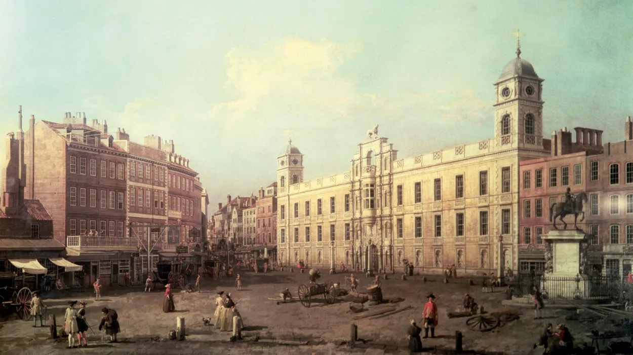
From roughly the twelfth century through the seventeenth century, the Strand was famous for a sequence of grand residences standing between the road and the Thames. These were not suburban villas. They were London power houses: urban bases for bishops, nobles, and ministers whose political lives required constant movement between court, Parliament, church institutions, and the City.
Among the most important were Savoy Palace, Somerset House, Durham House, York House, Essex House, Arundel House, and Cecil House. Most do not survive, but they shaped the district for centuries. Their presence explains why the Strand acquired a reputation for wealth and authority long before it became associated with hotels, theatres, and publishing.
The logic behind these residences was straightforward. Senior elites needed London accommodation, but not inside the crowded mercantile core of the City. The Strand offered river access, large plots, and rapid movement to Westminster. The river side of the road was especially valuable because households could maintain private stairs to the Thames. Before modern street transport, this was a major advantage.
Savoy Palace was among the greatest of the medieval Strand residences. Built as a major noble house, it later became associated with John of Gaunt, Duke of Lancaster. It was destroyed during the Peasants’ Revolt of 1381, one of the most significant episodes of urban unrest in medieval England. Its destruction shows that the Strand was already tied to national politics and class conflict, not merely domestic architecture.
The Tudor period intensified this pattern. The most famous intervention came with Somerset House. In 1539, Edward Seymour, brother of Jane Seymour and uncle to Edward VI, obtained property on the Strand and began building an enormous palace after becoming Duke of Somerset and Lord Protector. The project symbolised the political concentration of power under the Tudor state. It also demonstrated how the Strand functioned as a theatre of status. A great residence there was not just a home. It was a public declaration of access to monarchy and government.
Arundel House and York House similarly linked the Strand to elite patronage networks. Arundel House became associated with the Howard family and with important art and antiquities collections. York House was linked to powerful ecclesiastical and court figures. Collectively, these houses made the Strand a ribbon of influence along the Thames.
Why did the aristocratic Strand decline as a residential district?
The Strand ceased to be a dominant aristocratic residential street because London’s elite shifted westward, old mansions were demolished or subdivided, and the area became more commercial, institutional, and congested. Its social role changed from noble residence to mixed urban corridor.
By the seventeenth century, London’s geography of prestige was changing. The court and aristocracy increasingly favoured newer districts farther west, including St James’s, Mayfair, and other developing West End areas. These neighbourhoods offered more modern layouts, larger planned estates, and separation from the dense commercial traffic of the Strand and the City.
As elite residents moved, Strand mansions became vulnerable to redevelopment. Some were demolished outright. Others were broken into smaller plots and replaced with streets, shops, offices, taverns, and speculative housing. The decline was not sudden, and it did not erase prestige overnight, but it marked a structural shift. The Strand stopped being primarily a noble address and became a mixed-use urban street.
This process can be seen in the fate of houses such as Arundel House, whose grounds later generated new street patterns including Norfolk Street, Surrey Street, and Arundel Street. Such subdivisions turned private aristocratic land into urban fabric. A palace district became a street network. That change was one of the defining mechanisms by which early modern London expanded. Land once held in elite compounds was opened, parcelled, and monetised.
The commercialisation of the Strand also reflected broader economic change. By the eighteenth century the route was increasingly known for taverns, coffee houses, print sellers, and retail premises. It retained high-status institutions, but its social character diversified. This was the point at which the Strand began to resemble the urban artery familiar to modern London rather than the palace-lined riverside of the Tudor and Stuart eras.
How did religion, law, and monarchy shape the Strand’s identity?
Religion, law, and monarchy shaped the Strand by placing churches, legal institutions, and ceremonial gateways directly on the route between Westminster and the City. The street became both a physical connection and a symbolic stage for royal entry, judicial authority, and ecclesiastical presence in central London.
The eastern Strand is especially important for understanding this institutional identity. At its end stood Temple Bar, the historic boundary marker between Westminster and the City of London. Temple Bar was more than a traffic point. It was the principal ceremonial entrance into the City from Westminster. Monarchs traditionally paused there before entering the City, where they were met by the Lord Mayor of London in a ritual acknowledging the City’s privileges and loyalty to the Crown. That custom reveals the constitutional meaning of the Strand. It was the road along which political theatre became visible.
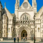
Temple Bar also marked entry to the legal quarter associated with the Inner Temple and Middle Temple, the Inns of Court that trained barristers and housed legal communities. The Strand therefore sat beside one of the central zones of English legal culture. In the nineteenth century this legal identity was reinforced by the construction of the Royal Courts of Justice just north of the Strand near Temple Bar, consolidating the area’s long relationship with law.
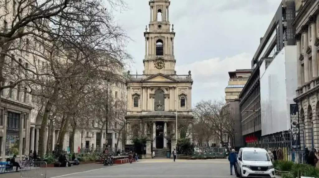
Religion is equally important. The Strand contains two highly significant churches often described as its “island churches” because road layouts later isolated them in traffic islands: St Clement Danes and St Mary le Strand. St Clement Danes has medieval origins but is primarily known through the post-Great Fire rebuilding associated with Sir Christopher Wren, completed in 1682, with later additions. St Mary le Strand, designed by James Gibbs and completed in 1717, is one of the most distinctive early eighteenth-century churches in London. These churches are not decorative side notes. They show how the Strand absorbed the rebuilding and formalisation of London after the seventeenth-century crises of plague, fire, and state reconstruction.
The Strand’s churches also preserve the street’s social breadth. Parish churches served local residents, travellers, workers, and elites alike. Their continued presence anchors the road’s historical continuity even as surrounding buildings changed.
What changed on the Strand in the eighteenth and nineteenth centuries?
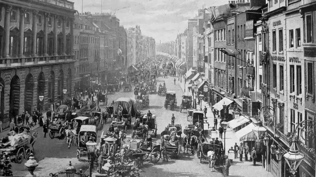
In the eighteenth and nineteenth centuries, the Strand changed from a former palace corridor into a dense commercial, cultural, and institutional street. Taverns, coffee houses, shops, publishers, hotels, theatres, colleges, and major road improvements turned it into one of central London’s busiest urban thoroughfares.
This was the period when the Strand became recognisably modern. Several developments converged.
First, the street’s old aristocratic identity gave way to a public urban culture. Coffee houses and taverns became important meeting places. The Strand was increasingly associated with conversation, news, politics, print, and sociability. Businesses that survive in historical memory, such as Twinings, established on the Strand in 1706, illustrate the commercial continuity of the route. Print sellers and publishers also operated there, reflecting the rise of metropolitan consumer culture.
Second, the theatre district expanded around the Strand and nearby Aldwych and Covent Garden. Music halls, theatres, hotels, and restaurants made the area a centre of entertainment. The Strand’s role in performance culture was not accidental. It sat at the junction of affluent West End audiences, legal and commercial workers, visitors arriving from the City, and tourists drawn to central London. That created a reliable market for leisure businesses. The now-lost Royal Strand Theatre, opened in 1832, was one expression of this wider theatrical environment.
Third, education and public institutions strengthened the street’s authority. King’s College London, founded in 1829, established one of its principal campuses on the Strand. This brought a major academic institution into a district already associated with law, publishing, and church life. The Strand thus became not only a place of movement and commerce but also of instruction and scholarship.
Fourth, nineteenth-century urban engineering transformed the area’s physical form. Street widening, demolition of old courts and alleys, and the creation of Aldwych and Kingsway in the late nineteenth and early twentieth centuries reconfigured traffic patterns. The construction of the Victoria Embankment between 1865 and 1870 pushed the Thames edge southward and replaced the earlier, messier riverside relationship with a more formal embanked frontage. This fundamentally changed how the Strand related to the river. It ceased to be a literal shoreline road and became an inland artery overlooking a newly engineered embankment zone.
These changes did not erase the Strand’s history. They layered new functions over old ground. A former palace district became a corridor of hotels, institutions, and entertainment without losing its political and ceremonial associations.
How did twentieth-century rebuilding and traffic planning reshape the Strand?
Twentieth-century planning reshaped the Strand by prioritising traffic circulation, redeveloping damaged sites, and embedding modern institutions within historic fabric. War damage, office construction, and road engineering altered the streetscape, but the Strand retained its ceremonial churches, legal landmarks, and educational institutions.
The twentieth century subjected the Strand to the same pressures felt across central London: motor traffic, war damage, office demand, and redevelopment. Yet the street remained a route of continuity.
One major factor was the growth of vehicular traffic. The Strand became part of a major east–west route through central London, now linked to the A4. This intensified pressure on historic buildings and altered the pedestrian experience. Road engineering around Aldwych and the island churches changed how the street was navigated and perceived.
The Second World War also affected the area. St Clement Danes was heavily damaged during the Blitz and later restored, reopening in 1958 as the central church of the Royal Air Force. This postwar adaptation gave the building a new national role while preserving its place in the Strand’s historical sequence. The church is therefore a good example of continuity through reuse: medieval foundation tradition, Wren rebuilding, wartime destruction, and modern memorial identity in one structure.
Twentieth-century redevelopment also altered former mansion plots and side streets. Office blocks replaced older buildings on some sites. Nearby properties connected to the Strand, such as parts of the Arundel and Norfolk Street area, were cleared or rebuilt in modern forms. Yet the Strand did not lose its concentration of historic institutions. Somerset House survived and evolved into a major cultural complex. King’s College London remained a defining presence. The legal quarter around Temple Bar and the Royal Courts of Justice continued to anchor the eastern end.
This balance between loss and survival is central to the Strand’s story. It is not a preserved museum street frozen in one century. It is a working route whose historical significance lies precisely in the coexistence of medieval alignment, early modern churches, Georgian and Victorian institutions, imperial offices, postwar reconstruction, and modern traffic infrastructure.
Which historic buildings and sites still show the Strand’s past today?
The Strand’s history remains visible in surviving landmarks such as Somerset House, St Clement Danes, St Mary le Strand, King’s College London, the Royal Courts of Justice, and the Temple Bar site. Together they preserve evidence of aristocratic, religious, legal, educational, and ceremonial London across many centuries.
The most important surviving Strand landmark is Somerset House. Although the current building is largely an eighteenth-century reconstruction rather than Edward Seymour’s original Tudor palace, the site preserves the memory of the Strand’s palace era and its riverfront power geography. Somerset House now functions as a major arts and cultural venue, but historically it represents aristocratic ambition, royal appropriation, state administration, and monumental urban design.
St Clement Danes and St Mary le Strand remain essential to understanding the street’s ecclesiastical and architectural history. They also demonstrate how post-Fire London inserted formal church architecture into one of the city’s busiest routes. Their survival is especially important because so many of the Strand’s great mansions have disappeared.
King’s College London Strand Campus represents the nineteenth-century educational turn in the street’s history. It shows how the Strand moved beyond noble residence into the world of modern institutions, scholarship, and public life.
At the eastern end, the Temple Bar site remains symbolically crucial even though Wren’s bar was removed in the nineteenth century and later reconstructed near St Paul’s Cathedral in the City. The original location still marks the old threshold between Westminster and the City, and the ceremonial meaning of that boundary remains part of London’s constitutional geography. Nearby, the Royal Courts of Justice embody the Strand’s legal dimension and the concentration of state authority at this end of the road.
Other remnants include street names preserving vanished mansions and estates, institutional sites linked to publishing and hospitality, and the broader urban pattern of lanes and courts running south toward the river or north toward Covent Garden and the legal quarter. These fragments matter because the Strand’s history survives not only in famous monuments but also in the structure of the district itself.
To experience this historic corridor in person today, consult our comprehensive [A Walking Guide to The Strand: Palaces, Churches and Cultural Landmarks] for itineraries and visiting parameters.
Why does the Strand still matter in London’s history today?
The Strand still matters because it condenses the making of London into one street: river geography, medieval urban growth, aristocratic residence, royal ceremony, legal authority, church rebuilding, commercial expansion, higher education, and heritage preservation all remain legible along its route.
Few London streets carry so many layers of national history in such a short distance. The Strand records the shift from Anglo-Saxon riverside route to medieval connector between rival centres, from palace zone to commercial thoroughfare, from ceremonial threshold to modern cultural district. It also demonstrates how London grows: not by replacing one identity with another, but by accumulating functions over time.
For historians, the Strand is a case study in urban continuity. It shows how roads generate institutions; how elite housing yields to commercial redevelopment; how churches and colleges stabilise a district; how river engineering changes land values and urban form; and how ceremonial boundaries survive even after their physical markers move. For cultural tourists, it offers one of the most efficient historical walks in central London because the evidence of these transformations remains unusually concentrated. For educators and genealogical researchers, the Strand provides access to the legal, ecclesiastical, academic, and administrative histories that shaped London families, professions, and public life.
Its long-term significance also lies in preservation. The Strand has lost many of its greatest buildings, including most of its aristocratic mansions. Yet the street still preserves enough fabric, alignments, and institutional continuity to explain the vanished city. In heritage terms, that makes it exceptionally valuable. It is not simply a road with old buildings on it. It is one of the clearest surviving frameworks for understanding how London’s political west and commercial east were joined into a single metropolis.
That is why the Strand became one of London’s most historic streets. It was the road between powers, the address of elites, the threshold of the City, the neighbour of the law, the site of churches and colleges, and the stage on which centuries of urban change were built. Its history is the history of London in linear form.
What is the Strand in London?
The Strand is a historic road in central London that runs between Trafalgar Square and Temple Bar. For centuries, it served as the main route linking the political centre of Westminster with the commercial centre of the City of London.