London’s canal network offers some of the capital’s most tranquil landscapes while revealing over 200 years of industrial, architectural, and social history. Originally engineered to transport coal, timber, grain, and manufactured goods during the Industrial Revolution, these waterways have evolved into protected green corridors where heritage structures, wildlife habitats, historic warehouses, and waterside communities coexist. Today, London’s canals provide peaceful walking routes, outstanding photography opportunities, and valuable insights into the city’s commercial and cultural transformation.
- Why are London’s canal walks historically significant?
- Which canal walk best represents London’s historic waterways?
- How did Little Venice become one of London’s most peaceful canal destinations?
- What makes Camden Lock an important part of canal history?
- Why does Regent’s Park provide a unique canal walking experience?
- How does King’s Cross showcase canal heritage through regeneration?
- What historic features can visitors discover along Limehouse Basin?
- Why are London’s canal towpaths ideal for peaceful sightseeing?
- What architectural styles define London’s canal landscapes?
- How do London’s canals support wildlife and environmental conservation?
- Why do London’s canals remain important cultural landscapes today?
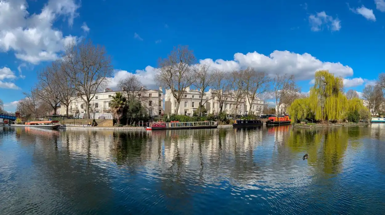
From the tree-lined banks of Regent’s Canal to the revitalised waterways surrounding Little Venice and Limehouse Basin, canal walks allow visitors to experience a quieter side of London beyond its busiest streets. Historic bridges, Victorian engineering, preserved lock systems, converted warehouses, and colourful narrowboats illustrate how the capital adapted to changing patterns of transport and urban development over two centuries.
Understanding these canal walks requires exploring their historical origins, engineering achievements, ecological importance, architectural character, and continued role in London’s modern landscape.
Why are London’s canal walks historically significant?
London’s canal walks follow waterways constructed between the late eighteenth and early nineteenth centuries to support Britain’s Industrial Revolution. These engineered routes transformed commerce, connected factories with docks, encouraged urban expansion, and remain remarkably preserved examples of Britain’s industrial heritage within a modern capital city.
Before canals, heavy cargo travelled slowly over poorly maintained roads. Britain’s expanding industries demanded faster and more reliable transport networks. Canal construction answered this need by creating navigable waterways capable of moving large quantities of goods at lower cost.
London’s canal history accelerated after the opening of the Grand Junction Canal in 1805 and Regent’s Canal in 1820. Together they connected the River Thames with England’s growing inland canal system.
The engineer John Nash incorporated Regent’s Canal into his wider vision for North London. The canal linked industrial districts with London’s West End while supporting commercial activity around newly developed neighbourhoods.
Warehouses, timber yards, coal depots, breweries, and gasworks quickly appeared beside canal banks. Horses pulled cargo boats along towpaths that remain walking routes today.
Unlike many industrial transport systems demolished during twentieth-century redevelopment, much of London’s canal infrastructure survived. Locks, bridges, tunnels, wharves, and basins still illustrate nineteenth-century engineering techniques.
These waterways also demonstrate Britain’s transition from water transport to railways during the Victorian period. Although commercial freight declined after railway expansion, the canal network continued serving industry well into the twentieth century.
Today the historic routes provide both recreational landscapes and living evidence of London’s industrial evolution.
Which canal walk best represents London’s historic waterways?
Regent’s Canal represents London’s historic canal system most completely because it combines early nineteenth-century engineering, preserved industrial architecture, historic markets, landscaped parks, residential districts, and active waterways across more than 13 kilometres through central London.
Regent’s Canal stretches from Little Venice in west London to Limehouse Basin in east London.
Completed in 1820 after several years of construction, the canal connected the Grand Junction Canal with the River Thames, creating an efficient commercial transport corridor across the city.
Walking along Regent’s Canal reveals numerous layers of London’s history.
Near Little Venice, elegant Regency architecture reflects early nineteenth-century urban planning. Around Camden, former warehouses and horse stables illustrate industrial expansion during the Victorian era.
The route continues through Regent’s Park, where landscaped gardens contrast sharply with nearby commercial infrastructure.
King’s Cross demonstrates successful heritage regeneration. Former Victorian warehouses now accommodate offices, educational institutions, restaurants, and cultural venues while preserving original brickwork and industrial character.
Further east, the canal passes through Islington Tunnel, one of London’s major nineteenth-century engineering achievements. Although pedestrians use an alternative route above ground, the tunnel remains an important historic feature.
Approaching Limehouse Basin, visitors encounter connections with London’s maritime history and the River Thames.
To experience these historic waterways in person today, consult our comprehensive [Why London’s Historic Canals Were Built and Their Lasting Importance Today] for itineraries and visiting parameters.
How did Little Venice become one of London’s most peaceful canal destinations?
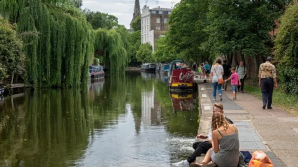
Little Venice developed after the opening of the Paddington Arm of the Grand Junction Canal in 1801. Elegant nineteenth-century housing, intersecting waterways, landscaped surroundings, and careful conservation created one of London’s most distinctive waterside neighbourhoods.
Little Venice occupies the junction where Regent’s Canal meets the Paddington Arm.
The district gradually evolved during the nineteenth century as wealthy residents settled around newly constructed terraces overlooking the waterways.
Unlike heavily industrial sections elsewhere, Little Venice developed primarily as an attractive residential neighbourhood.
White stucco houses designed during the Regency and Victorian periods still overlook the basin.
Colourful narrowboats now occupy moorings once used by commercial cargo vessels.
Mature trees, waterside cafés, and carefully maintained gardens create peaceful scenery that differs dramatically from central London’s busy commercial districts.
Wildlife also contributes to the area’s appeal. Swans, ducks, coots, moorhens, and herons regularly inhabit the waterways, creating opportunities for nature photography throughout the year.
Historic canal bridges frame reflections across calm water, making Little Venice one of London’s most photographed canal locations.
Its conservation status has protected much of its original nineteenth-century architectural character.
What makes Camden Lock an important part of canal history?
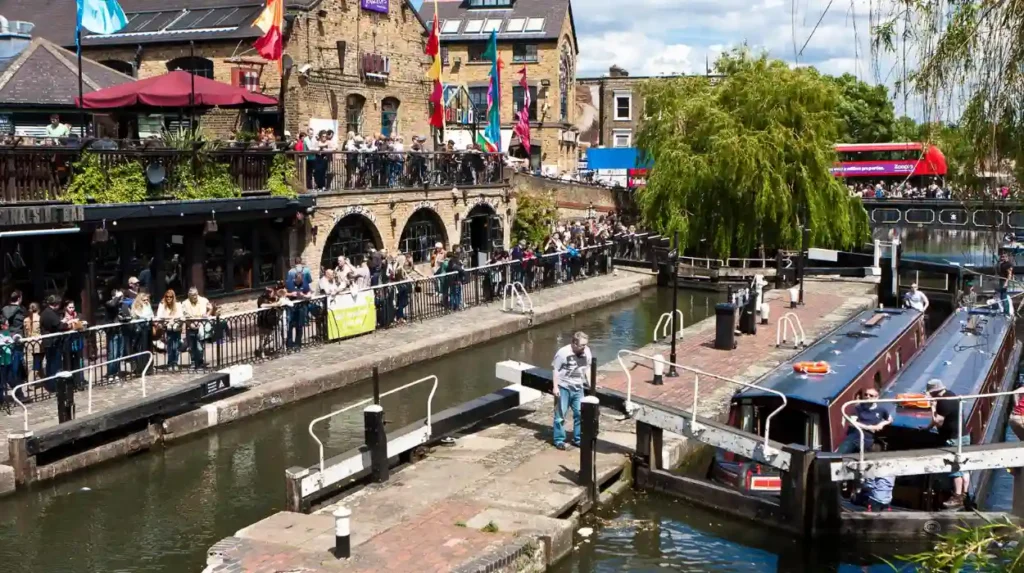
Camden Lock demonstrates how industrial transport infrastructure evolved into one of London’s leading cultural destinations. Historic lock engineering, preserved warehouses, former horse facilities, and adaptive reuse illustrate changing economic patterns across two centuries of urban development.
Camden Lock forms one of Regent’s Canal’s busiest historic sections.
Constructed during the early nineteenth century, the lock regulated water levels as cargo boats transported goods between London’s markets and manufacturing districts.
The surrounding area became an important commercial centre.
Timber merchants, grain warehouses, breweries, and stables supported canal operations.
The horse tunnel beneath nearby roads allowed tow horses to continue pulling boats efficiently through busy urban environments.
During the late twentieth century, declining industrial activity created opportunities for regeneration.
Former warehouses became market buildings, retail spaces, restaurants, and performance venues.
Despite these changes, many original industrial structures remain visible.
Lock gates continue operating, providing visitors with opportunities to observe traditional canal engineering in action.
The combination of industrial heritage and contemporary cultural activity makes Camden one of London’s most significant examples of successful heritage conservation.
Why does Regent’s Park provide a unique canal walking experience?
Regent’s Park combines formal landscape architecture with historic waterways, creating one of London’s most scenic canal environments. Designed during the Regency era, the park preserves carefully planned green spaces alongside nineteenth-century engineering and abundant urban biodiversity.
Regent’s Park occupies a central section of the Regent’s Canal route.
The park formed part of architect John Nash’s comprehensive redevelopment plan commissioned by the Prince Regent during the early nineteenth century.
Unlike industrial canal stretches, this section prioritises landscape beauty.
Broad lawns, mature trees, ornamental gardens, and open views surround the canal.
Pedestrians frequently observe waterfowl including mute swans, mallards, tufted ducks, and Canada geese.
Seasonal changes dramatically alter photographic opportunities.
Spring blossoms, summer greenery, autumn foliage, and winter reflections create diverse visual compositions throughout the year.
Historic bridges crossing the canal provide elevated viewpoints for photographing narrowboats passing beneath.
The park demonstrates how engineered waterways became integrated into urban recreational landscapes during London’s expansion.
How does King’s Cross showcase canal heritage through regeneration?
King’s Cross preserves Victorian industrial infrastructure while adapting historic warehouses, granaries, and railway facilities for modern educational, commercial, and cultural uses. This regeneration demonstrates how heritage conservation supports sustainable urban redevelopment without erasing historical identity.
King’s Cross emerged during the nineteenth century as one of London’s largest transport and distribution centres.
Its location beside Regent’s Canal enabled efficient movement of goods between waterways and expanding railway networks.
Granary Square, Coal Drops Yard, and surrounding warehouses originally stored coal, grain, and imported commodities.
These structures featured robust brick construction, cast-iron columns, and large loading bays designed for commercial operations.
Extensive regeneration during the twenty-first century retained many historic buildings while introducing new public spaces.
Universities, technology companies, restaurants, galleries, and cultural institutions now occupy former industrial premises.
Canal-side walkways connect restored bridges, historic lock structures, and landscaped public squares.
Architectural preservation illustrates how industrial heritage contributes to contemporary urban identity.
Photographers often capture striking contrasts between restored Victorian brickwork and modern glass buildings reflected in the canal.
What historic features can visitors discover along Limehouse Basin?
Limehouse Basin connects Regent’s Canal with the River Thames through one of London’s oldest dock districts. Maritime infrastructure, historic locks, surviving warehouses, and commercial port heritage illustrate Britain’s global trading expansion during the nineteenth century.
Limehouse Basin originally opened in 1820 as the eastern terminus of Regent’s Canal.
Its purpose was straightforward.
Cargo arriving from inland canals transferred directly onto ships navigating the River Thames.
This connection strengthened London’s position as Britain’s principal commercial port during the nineteenth century.
The basin underwent several enlargements as maritime trade expanded.
Historic lock systems regulated changing tidal conditions between the canal and river.
Nearby warehouses stored imported commodities including tea, timber, grain, sugar, and manufactured goods.
Dock workers, merchants, boatmen, and shipbuilders formed thriving communities throughout the surrounding neighbourhoods.
Modern residential developments now overlook preserved maritime infrastructure.
Interpretation panels explain the basin’s commercial significance while restored lock gates remain operational.
The mixture of historic engineering and contemporary waterfront architecture creates excellent opportunities for documentary photography.
Why are London’s canal towpaths ideal for peaceful sightseeing?
London’s canal towpaths preserve uninterrupted walking routes separated from major traffic corridors. Originally built for horses pulling cargo boats, these historic paths now provide accessible green spaces, wildlife habitats, and quiet observation points throughout the capital.
Towpaths formed an essential part of canal operations.
Before steam-powered vessels, horses walked beside canals pulling heavily loaded narrowboats using long tow ropes.
These paths therefore required stable surfaces and continuous access along the waterways.
Following the decline of commercial boating, towpaths gradually became recreational routes.
Today many sections accommodate walkers and cyclists while preserving their historic alignment.
The absence of heavy vehicle traffic creates noticeably quieter environments than surrounding streets.
Tree canopies reduce urban noise while continuous waterways produce visually calming landscapes.
Historic milestones, lock mechanisms, bridges, tunnels, and mooring points remain visible along many routes.
These surviving features allow visitors to observe Britain’s industrial transport history within everyday urban settings.
Towpaths also connect parks, conservation areas, residential districts, and cultural attractions without requiring extensive road crossings.
What architectural styles define London’s canal landscapes?
London’s canal landscapes display Georgian planning, Regency elegance, Victorian industrial architecture, Edwardian commercial buildings, and contemporary adaptive reuse. Together these architectural layers document more than two centuries of continuous urban development surrounding historic waterways.
Canal architecture reflects changing periods of London’s growth.
Georgian buildings appear around early residential developments near Little Venice.
Regency terraces feature symmetrical façades, stucco finishes, decorative balconies, and carefully proportioned windows.
Victorian industrial architecture dominates areas including Camden, King’s Cross, and Limehouse.
Large brick warehouses incorporate arched openings, loading doors, cast-iron structural elements, and practical engineering solutions.
Historic canal bridges vary considerably.
Examples include cast-iron bridges, brick arch bridges, stone structures, and later steel replacements.
Lock cottages illustrate domestic architecture associated with canal operations.
Many remain occupied while preserving traditional external appearance.
Modern architecture now complements rather than replaces surviving heritage buildings.
Glass residential developments frequently overlook restored warehouses, demonstrating successful integration of historic preservation with contemporary construction.
This architectural diversity creates visually rich environments valued by historians, architects, and photographers alike.
How do London’s canals support wildlife and environmental conservation?
London’s historic canals function as valuable ecological corridors supporting aquatic species, birds, insects, and waterside vegetation. Conservation programmes protect biodiversity while maintaining historic waterways that connect parks, nature reserves, and green infrastructure across the capital.
Although engineered for transport, canals now support extensive urban biodiversity.
Aquatic habitats provide suitable environments for fish, including perch, roach, and pike.
Bird species regularly observed include grey herons, kingfishers, mute swans, mallards, coots, and moorhens.
Dragonflies, damselflies, butterflies, and bees benefit from waterside vegetation planted during habitat restoration initiatives.
Native plants stabilise canal banks while improving water quality.
The Canal & River Trust manages significant sections of London’s waterways through ecological monitoring, habitat improvement, and heritage conservation.
Green corridors also assist wildlife movement between larger parks.
Examples include Regent’s Park, Victoria Park, and numerous local nature reserves connected through canal systems.
Environmental management demonstrates how historic engineering infrastructure contributes to modern urban sustainability.
Why do London’s canals remain important cultural landscapes today?
London’s canals preserve nationally significant industrial heritage while providing recreation, education, biodiversity, and sustainable transport corridors. Their continued protection demonstrates how historic infrastructure adapts successfully to modern urban life without losing historical authenticity.
Canals no longer dominate commercial transport, yet their cultural importance continues expanding.
Educational institutions use canal environments to teach industrial history, engineering, architecture, geography, ecology, and urban planning.
Heritage organisations preserve original lock mechanisms, warehouses, bridges, and navigation structures.
Conservation policies protect historic character while accommodating residential development and public access.
Walking, cycling, boating, photography, birdwatching, and heritage tourism generate sustained public interest throughout the year.
Researchers studying genealogy also benefit because canal communities left extensive historical records documenting boat families, dock workers, merchants, and industrial labourers connected with London’s waterways.
Photography continues documenting seasonal changes across preserved historic environments.
Morning light, autumn foliage, winter mist, and evening reflections produce varied visual conditions that attract both amateur and professional photographers.
More than two centuries after their construction, London’s canals continue fulfilling public purposes through recreation, education, heritage preservation, environmental conservation, and cultural identity.
Rather than existing as relics of Britain’s industrial past, these waterways remain active components of London’s living historical landscape. Every preserved lock, bridge, warehouse, basin, and towpath contributes evidence of the capital’s commercial expansion, engineering innovation, and urban transformation. Walking beside these canals allows visitors to experience history within authentic settings where nineteenth-century infrastructure continues serving twenty-first-century communities.
For historians, educators, tourists, photographers, and local residents alike, London’s canal walks provide an enduring connection between the city’s industrial origins and its modern commitment to conserving historic places for future generations.
What is the most scenic canal walk in London?
Regent’s Canal is widely considered London’s most scenic canal walk. It stretches from Little Venice to Limehouse Basin, passing through Regent’s Park, Camden Lock, King’s Cross, and several historic neighbourhoods.