The Prime Meridian is the mathematically designated line of zero degrees longitude that divides the Eastern and Western Hemispheres of Earth. It sits permanently in Greenwich, London, because historic British astronomical innovations and global maritime dominance dictated world map standardisation.
- How Did The Royal Observatory Greenwich Become The Center Of Global Time?
- What Occurred At The International Meridian Conference Of 1884?
- Who Were The Key Historical Figures Behind Greenwich Mean Time?
- How Does The Airy Transit Circle Define The Meridian Line?
- Why Is Greenwich Mean Time Different From Modern Coordinated Universal Time?
- What Preservation Efforts Protect The Historic Royal Observatory?
- How Significant Is The Prime Meridian In The Age Of Satellite Navigation?
The exact geographic location of the Prime Meridian is defined by the position of the Airy Transit Circle telescope. This specific astronomical instrument was built by the Seventh Astronomer Royal, Sir George Biddell Airy, in the year 1851 at the Royal Observatory in Greenwich. Longitude is the angular measurement of a place east or west of a reference line. Unlike the equator, which is dictated by the rotational axis of the Earth, a prime meridian is entirely arbitrary. Historically, nations established their own base meridians for domestic navigation and mapping.
The consolidation of global trade and the expansion of transnational railway networks during the nineteenth century created an urgent requirement for a singular, internationally recognized baseline. Great Britain possessed the most advanced cartographic infrastructure of the era. By the late nineteenth century, the vast majority of global shipping tonnage relied on navigation charts calculated from the zero point at Greenwich. This deep economic dependency culminated in the official international selection of the site as the mathematical anchor for global time and space.
How Did The Royal Observatory Greenwich Become The Center Of Global Time?
The Royal Observatory Greenwich became the center of world time through its systematic development of astronomical solutions for marine navigation. Founded by King Charles II in 1675, the institution successfully resolved the critical problem of measuring longitude at sea.
The initial foundation of the Royal Observatory occurred on June 22, 1675, when King Charles II signed a royal warrant appointing John Flamsteed as the first Astronomer Royal. The primary mandate of the institution was to rectify the motions of the ditto celestial bodies and the places of the fixed stars, to find out the so-much-desired longitude of places, for the perfecting of the art of navigation. Navigators at sea required precise star catalogues to determine their position relative to a known home port. The location chosen was Greenwich Castle, a hilltop site in Greenwich Park that offered an elevated vantage point away from the industrial smoke of central London.
Throughout the eighteenth century, the Royal Observatory produced highly accurate astronomical observations that formed the basis of the British Nautical Almanac, first published by Nevil Maskelyne in 1767. This publication allowed sailors to calculate their distance from the Greenwich meridian using the lunar distance method. Concurrently, clockmaker John Harrison developed accurate marine chronometers, including the famous H4 timekeeper completed in 1759, which maintained Greenwich time on long sea voyages. The combination of astronomical tables and mechanical precision ensured that British vessels systematically calculated their geographic position relative to Greenwich, embedding the location into global maritime practice.
What Occurred At The International Meridian Conference Of 1884?
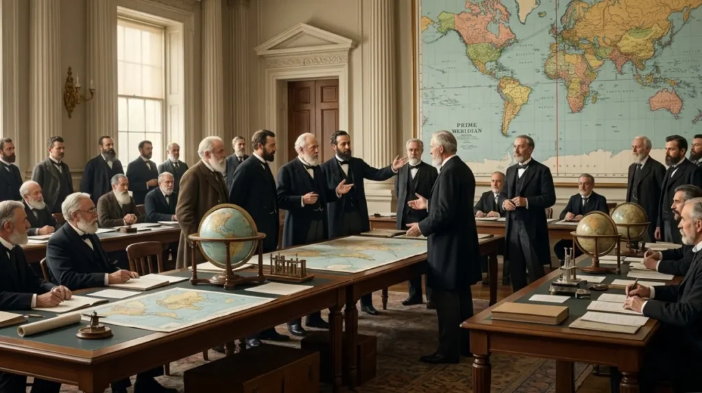
The International Meridian Conference of 1884 formally established the Greenwich meridian as the single, official zero-degree reference line for the entire world. Twenty-five nations gathered in Washington, D.C., to debate and vote on the global cartographic standard.
United States President Chester A. Arthur convened the International Meridian Conference in October 1884 following a growing international consensus that multiple reference meridians disrupted telegraphic communications and railway schedules. Forty-one delegates representing 25 nations examined several proposals, including a completely neutral meridian based on the Azores or the Bering Strait. The final selection required a baseline that was already supported by extensive, highly accurate, and readily available mapping data to minimize worldwide printing costs.
The statistical dominance of British charts decided the vote. Data presented at the conference showed that 72 percent of the world’s commerce already utilized navigation charts based on the Greenwich meridian, while only 8 percent used the Paris meridian. On October 22, 1884, Resolution II passed with an overwhelming majority, declaring the adoption of the meridian passing through the Observatory of Greenwich as the initial meridian for longitude. Twenty-two nations voted in favor of the Greenwich resolution, San Domingo voted against it, and France and Brazil abstained from the vote.
Who Were The Key Historical Figures Behind Greenwich Mean Time?
The creation of Greenwich Mean Time depended on consecutive British astronomers, monarchs, and clockmakers who engineered precision instruments. Key figures include King Charles II, John Flamsteed, John Harrison, and the innovative engineer Sir George Biddell Airy.
The institutional lineage of the Royal Observatory includes several critical pioneers who advanced the science of chronometry and transit observation. To experience this historic landmark in person today, consult our comprehensive [Visitor Guide to Greenwich Heritage Sites] for itineraries and visiting parameters. Each figure contributed specific technological improvements that built global trust in the accuracy of Greenwich data.
- King Charles II: The sovereign who authorized the construction of the building and established the office of Astronomer Royal in 1675.
- John Flamsteed: The first Astronomer Royal who spent over 40 years cataloging 3,000 stars with unprecedented accuracy.
- John Harrison: The carpenter and clockmaker who spent decades perfecting precision marine chronometers that resisted the motion and temperature changes of sea travel.
- Sir George Biddell Airy: The Seventh Astronomer Royal who constructed the Airy Transit Circle in 1851, which physically defines the exact line of the Prime Meridian.
The architectural layout of the observatory directly reflects these contributions. Flamsteed House, designed by Sir Christopher Wren and completed in 1676, served as the original observatory building and domestic quarters for the astronomers, housing precision pendulum clocks and early quadrant telescopes.
How Does The Airy Transit Circle Define The Meridian Line?
The Airy Transit Circle defines the meridian line by anchoring a massive, pivoting telescope to heavy stone foundations aligned precisely with the north-south meridian. This telescope measures the exact moment a star passes the local overhead line.
Commissioned in 1851, the Airy Transit Circle is a specialized astronomical instrument used to determine both time and the positions of celestial objects. It consists of a 12-foot focal length telescope mounted on a rigid horizontal axis supported by massive stone piers. The telescope can only pivot along a single plane, looking directly along the local line of longitude. As the Earth rotates, stars appear to cross this vertical crosshair, an event known as a meridian transit.
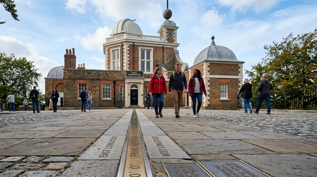
By recording the precise time a specific star transits the telescope, astronomers calculated the exact rotational speed of the Earth and regulated the master clocks of the observatory. The center of the crosshairs inside this specific telescope lens structurally defines the line of zero degrees longitude. Because the international community adopted the Airy Transit Circle baseline during the 1884 vote, the physical brass and bronze strip set into the courtyard cobblestones outside this telescope room marks the official starting point of world geography.
Explore More History Of London
Inside Somerset House: History, Exhibitions & Courtyards – Strand
Temple Church and Knights Templar Legacy in Temple London
Why Is Greenwich Mean Time Different From Modern Coordinated Universal Time?
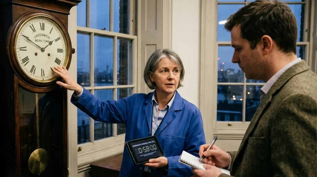
Greenwich Mean Time differs from Coordinated Universal Time because GMT relies directly on the variable rotational position of the Earth. Modern UTC relies on highly stable atomic clocks that measure the constant vibrations of cesium atoms.
Greenwich Mean Time is a solar time system that treats the length of a day as exactly 24 hours, calculated from the moment the sun transits the Greenwich meridian. However, the rotational speed of the Earth is not perfectly uniform due to tidal friction caused by the moon and complex fluid dynamics within the core of the planet. These factors cause the length of a solar day to fluctuate by fractions of a second over long periods, making astronomical time imperfect for modern telecommunications, satellite navigation, and global computer networks.
Coordinated Universal Time replaced GMT as the international time standard in the year 1972. UTC is regulated by the International Bureau of Weights and Measures using data from over 400 atomic clocks spread across the globe. To ensure that UTC remains synchronized with the actual rotation of the Earth, leap seconds are occasionally added to the atomic time scale. This mechanism ensures that the physical difference between atomic time and astronomical solar time never exceeds 0.9 seconds. Despite this modern shift to atomic measurement, UTC remains structurally anchored to the Greenwich baseline, meaning the international time zones remain calculated as offsets from the zero longitude reference point in London.
What Preservation Efforts Protect The Historic Royal Observatory?
Preservation efforts protect the Royal Observatory through strict statutory heritage listings and its inclusion within a United Nations World Heritage site. Historic England and the National Maritime Museum manage the structures to preserve the historic science spaces.
The complete complex of the Royal Observatory Greenwich is legally protected under United Kingdom planning law as a Grade I listed building, a designation reserved for structures of exceptional historic or architectural interest. In 1997, the United Nations Educational, Scientific and Cultural Organization inscribed Maritime Greenwich as a World Heritage Site. This specific designation covers several architectural structures, including the Old Royal Naval College designed by Sir Christopher Wren, the Queen’s House designed by Inigo Jones, and the expansive Royal Park that surrounds the observatory buildings.
The physical structures undergo continuous, highly detailed conservation work to counteract the structural degradation caused by environmental exposure and high visitor footfall. Conservators use traditional lime mortars and historical brick-matching techniques to maintain the external facades of Flamsteed House and the Meridian Building. Internally, the specialized instruments, including the Airy Transit Circle, the 28-inch Great Equatorial Telescope installed in 1893, and the original pendulum clocks constructed by Thomas Tompion, are kept in highly regulated environmental conditions to control humidity and temperature fluctuation, preventing metallic corrosion and wood warping.
How Significant Is The Prime Meridian In The Age Of Satellite Navigation?
The Prime Meridian remains highly significant as the historical foundation of global cartography, although modern satellite navigation systems use an alternate electronic baseline. Global Positioning System receivers utilize the WGS 84 reference frame, which sits 102 meters east of the historic line.
The advent of space-based satellite navigation systems in the late twentieth century required a truly geocentric coordinate reference model that evaluates the center of the total mass of the Earth. Modern systems use the World Geodetic System 1984, which calculates coordinates using satellite telemetry and orbital trajectories rather than surface-based telescope observations. Because the historic Airy Transit Circle was calibrated using local gravity vectors affected by the natural curvature of the local landscape and the mass of the Thames Valley, its astronomical vertical line is slightly offset from the absolute geometric center of the planet.
As a direct result of this technological evolution, the electronic zero longitude line utilized by all modern smartphones and flight navigation instruments sits approximately 102 meters east of the physical brass line at Greenwich. This electronic line is known as the IERS Reference Meridian. Despite this physical separation, the modern electronic system was intentionally aligned as closely as possible to the historic Greenwich standard to avoid disrupting existing global map archives. The physical line remains the primary educational monument dedicated to the history of global exploration, geographic mapping, and international scientific cooperation.
What is the Prime Meridian?
The Prime Meridian is the internationally recognised line of 0° longitude that divides the Earth into the Eastern and Western Hemispheres. It serves as the reference point for global mapping, navigation, and timekeeping.